Why we love old movie locations — especially the Iverson Movie Ranch

For an introduction to this blog and to the growing interest in historic filming locations such as the Iverson Movie Ranch — the most widely filmed outdoor location in movie and TV history — please read the site's introductory post, found here.
• Your feedback is appreciated — please leave comments on any of the posts.
• To find specific rock features or look up movie titles, TV shows, actors and production people, see the "LABELS" section — the long alphabetical listing on the right side of the page, below.
• To join the MAILING LIST, send me an email at iversonfilmranch@aol.com and let me know you'd like to sign up.
• I've also begun a YouTube channel for Iverson Movie Ranch clips and other movie location videos, which you can get to by clicking here.
• Readers can email the webmaster at iversonfilmranch@aol.com
.

Showing posts with label Tyler Malone. Show all posts

Tuesday, December 24, 2019

A movie location explorer's adventures on the Iverson Ranch — and in Lone Pine, Calif.

Tyler Malone peers around the "Sliver" near Desert Tortoise on the Lower Iverson

A relative newcomer to the Iverson Movie Ranch — and I can call him that because I've been studying the ranch for more than 11 years and I still consider myself a newcomer too — is movie location adventurer Tyler Malone.


Interactive map of the Iverson Movie Ranch and nearby filming locations

Tyler came out of the chute this year with guns blazing, contributing some nice rock finds along with his terrific interactive map of the Iverson Movie Ranch and nearby filming locations.

Here's where you can always find the interactive map

I know a number of readers have already become fans of Tyler's movie location research thanks to his interactive Iverson map. You can always link to it at the right of this page under "LABELS" — it's the first item.

If you'd like to learn more about the map and how it works, you can also click here to see the post we did back in September introducing the map — and you can link from that item to the map itself.

"Mystery Mountain" (Mascot serial, 1934)

Tyler recently set out to find a rock on the Lower Iverson that caught his eye in this promo still for the old Ken Maynard serial "Mystery Mountain." His successful search made it clear that he's a skilled rock sleuth.

In the photo, Edmund Cobb, in an uncredited role as "The Rattler," has our hero "Ken Williams," played by Ken Maynard, in a stranglehold.

Because of this shot, we began referring to the rock they're standing on as "Stranglehold Rock." But the key to finding it would turn out to be the rock in the bottom left corner.

Some readers may have already figured out where this discussion was headed, but I initially didn't recognize the "unknown rock," and Tyler surprised me when he said it was the Sphinx.

Markers identified on the Sphinx, as it appeared in "Mystery Mountain" in 1934

Tyler provided this shot identifying some of the markers on the rock that can be found in the "Mystery Mountain" stranglehold shot.

The same markers identified on the Sphinx as it appears today

He also pointed out the same markers in this recent photo of the Sphinx.

Stranglehold Rock and the Sphinx in a poster for Chapter 5

Something that surfaced a little bit later was this poster for one of the chapters of "Mystery Mountain," showing more of both the Sphinx and Stranglehold Rock. The Sphinx is easier to recognize here than in the promo still.

Target area for "Stranglehold Rock" (Google aerial view)

With the Sphinx identified the search area could be narrowed way down. Even so, finding Stranglehold Rock posed its share of challenges, as I found out when I poked around the target area and couldn't find it.

On one of Tyler's visits to the target zone he found a big, messy tree where he had determined Stranglehold Rock should be located.

Stranglehold Rock in 2019

Poking his head inside the morass of tangled brush under the tree, he found what he was looking for: Stranglehold Rock, engulfed by the tree and its scrubby ecosystem.

Tyler noted a few key markers on the rock to illustrate that it's the same rock appearing in "Mystery Mountain."

The markers can be seen again here, in a blowup from the "Mystery Mountain" poster. The shot also reveals where the actors' feet were positioned during the stranglehold sequence.

A Google aerial shows the Sphinx, in the red circle, and the Stranglehold Rock tree, marked by a blue arrow. The Garden of the Gods Trail, visible at top center, will get you there from your parking spot on Redmesa Road.

Ken Maynard on the Lower Iverson (promo still for "Mystery Mountain," 1934)

Another fun promo still from "Mystery Mountain" shows Ken Maynard taking aim from behind a sliver of a rock, which still stands today on the Lower Iverson Movie Ranch.

"Mystery Mountain": Ken Maynard behind the sliver

The promo still is based on this scene in the serial. As usual, the promo still is a huge improvement on the picture quality seen in the movie itself.

Tyler Malone takes cover behind the same "sliver" of a rock.

If the shot looks familiar, it's because of the picture of Tyler that appears at the top of this post. Tyler positioned himself behind the same rock sliver to re-create the "Mystery Mountain" shot.

It's kind of obvious here, but this is the rock I keep referring to as the "sliver."

It's probably a little less obvious in the promo still, because next to the sliver rock is another rock that also has "slivery" characteristics.

We can call this one "Rock B" for the time being, as it may help get a handle on some of the more interesting rocks in that corner of the Lower Iverson Movie Ranch.

"Mystery Mountain: A wider shot of Desert Tortoise and the "Sliver" rock

This wider shot from the same sequence in "Mystery Mountain" doesn't have nearly the detail of the promo still, but what it lacks in picture quality it makes up for by showing several of the area's key rocks.

The shot includes the "Sliver," with Ken Maynard behind it, along with "Rock B," a larger rock to its left that we can call "Rock C," and of course, Desert Tortoise, which is sort of the mother of all rocks in that immediate area.

"Mystery Mountain": The shootout, from Ken's side

The embarrassment of riches that is "Mystery Mountain" also offers this cool shot from a reverse angle.

Again, I wish the picture quality were better, but at least we can still make out the main features.

Desert Tortoise in modern times

Desert Tortoise is this big rock located just northwest of the main Garden of the Gods area. It was situated next to an old movie road and became one of the more heavily filmed rocks on the Lower Iverson.

Desert Tortoise in "Law of the Ranger" (Columbia, 1937)

I've blogged about Desert Tortoise before, and if you click here you can see a post about some of its movie history, along with an explanation of why I call it "Desert Tortoise" — and there's a map to help you find the rock.

The key features are identified again here, as seen in a screen shot from the Bob Allen Western "Law of the Ranger." Of the four rocks identified, only two — Desert Tortoise and the "Sliver" — have survived.

"Law of the Ranger" marked one of the final shoots for Rocks B and C, which were removed around 1937 — presumably so stagecoaches and groups of riders could more easily negotiate the road past Desert Tortoise.

"Days of Jesse James" (Republic, 1939)

By 1939, when Roy Rogers filmed "Days of Jesse James" on the Iverson Ranch, Rocks "B" and "C" were no longer in place and the road had been widened.

"Mystery Mountain": Ken Maynard stands on a mystery rock

Another interesting promo still from "Mystery Mountain" is this one showing Ken Maynard standing on a rock that Tyler and I have been searching for without any success. If you happen to recognize it, please get in touch.

"Bat Masterson" episode "Buffalo Kill" (1959): Buffalo Kill Rock

Stranglehold Rock isn't Tyler's first Iverson Movie Ranch find — he also found this rock, which had me stumped for some time. I've been calling it "Buffalo Kill Rock" because of the "Bat Masterson" episode where it appears.

Buffalo Kill Rock as it appears today

The rock doesn't look much like its "Bat Masterson" photo anymore — at least not from any angles we can see today. I talked about the discovery of this rock back in September, and you can read more about it here.

Promo still for "Excuse Me" (1925): Norma Shearer on "Excuse Me Point"

Tyler also tracked down a rock I call "Excuse Me Point," where Norma Shearer was filmed for the 1925 silent feature "Excuse Me." Click here to see a discussion of this find in the same September blog post.

"King of the Pecos" tour, 2019 Lone Pine Film Festival (Don Kelsen drone photo)

Something I didn't get to do this year was go to the annual Lone Pine Film Festival in October, but Tyler attended and reported back, including sending some cool photos from Lone Pine's Alabama Hills.

Natalie Wood in "The Great Race" (1965), and Tyler Malone visiting the same spot

Above is a screen shot of Natalie Wood in the Alabama Hills from "The Great Race." Below Natalie is Tyler's recent re-creation of the scene.

Kevin Bacon in the Alabama Hills in "Tremors" (1990), and Tyler's re-creation

The campy 1990 sci-fi/horror movie "Tremors," starring Kevin Bacon, filmed heavily in the Lone Pine area, and here Tyler gets down to about one degree of separation while re-creating a shot from the movie.

"Trail to San Antone" (Gene Autry, 1947): Stunt jump in the Alabama Hills

In this shot from Republic's "Trail to San Antone," a horse jumps over a car in the Alabama Hills.

The same location as it appears today

Tyler returned from Lone Pine with this photo of the location where the stunt jump was filmed. Snow-covered Lone Pine Peak can be seen in the background of both shots, above the distinctive vertical crack in the rock.

Gene Autry Rock — in "Boots and Saddles" (1937) and more recently

Speaking of Gene Autry, one of Lone Pine's most famous rocks is named after him. Here the curved rock tower known as "Gene Autry Rock" is seen with Autry in "Boots and Saddles" and with Tyler in a modern re-creation.

"Hop-a-Long Cassidy" (Paramount, 1935) — and Tyler's contemporary re-creations

The Western character most closely identified with Lone Pine is Hopalong Cassidy, so naturally Tyler has walked in the footsteps of the original "Hoppy," William Boyd.

A Greg Parker tour at the 2019 Lone Pine Film Festival

Sometimes we get fun reminders that Lone Pine and Iverson are both part of a larger community of movie location enthusiasts. On Lone Pine tour guide Greg Parker's "Hop-a-Long Cassidy" tour at this year's festival, Tyler and Greg found out they had both been looking for Iverson's elusive "Stranglehold Rock."

Have a cowboy Christmas (or holiday of your choice), everybody!

Saturday, September 21, 2019

Interactive map of the Iverson Movie Ranch


Interactive map of the Iverson Movie Ranch and nearby filming locations

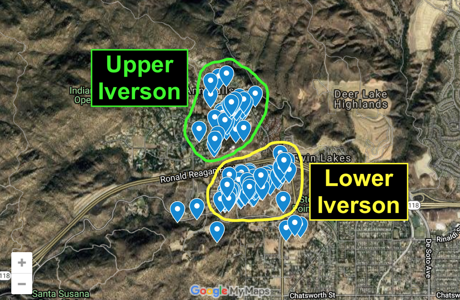
Movie location explorer Tyler Malone has created a map of famous rocks and filming sites on the Iverson Movie Ranch. You can see the Lower Iverson above, with each of the blue "tags" pointing to a movie rock.

It's interactive!

The map is interactive, so you should be able to click on individual tags to see details about particular rock features. You can also zoom in and out, or use your mouse to "drag" the map to move it around.

Use the "plus" and "minus" buttons to zoom in and out. This will only work on the map at the top of this post, so if you're trying to click on this image and it isn't working, you'll want to go back to the map up above.

This is just my way of emphasizing that only the map at the top of the post is interactive, so don't try to click on any of the other images — they're just illustrations. (But clicking on them will still bring up a larger image.)

The frame icon in the top right corner should take you to a larger version of the interactive map. Again, this will only work if you start with the map at the top of this post.

Zoom out to see the Upper and Lower Iverson combined

If you zoom out (by using the "minus" button), you can see both the Upper Iverson and the Lower Iverson.

In addition to the Upper and Lower Iverson, a few nearby filming locations are also tagged, such as the Spahn Ranch immediately to the southwest of the Lower Iverson and Stoney Point to the southeast.

Wide map of Santa Susana Mountains filming locations

If you zoom out even further, you'll see that Tyler's map extends to a few other locations in the Santa Susana Mountains, including Corriganville to the east and various Chatsworth filming sites southwest of the Iverson Ranch.

Three major filming areas in the Santa Susana Mountains

In addition to the two most heavily filmed movie ranches of all time — the Iverson Ranch and Corriganville — the map points the way to some fascinating and lesser-known Chatsworth filming sites, inside the green circle.

Zooming in on the Gorge, on the Lower Iverson

Here's an example of what the map looks like when you zoom in on a particular area — in this case we're seeing a section of the Upper Gorge below the condos on the Lower Iverson, along the eastern edge of Redmesa Road.

Interactive tag for "The Pit"

Tyler set up the map to interact with the Iverson Movie Ranch Blog, so if you click on a tag — for example, the tag noted here for "The Pit" — it brings up information from the blog, usually including a link.

Side panel with details about "The Pit"

Clicking on the tag for the Pit brings up a side panel containing a photo, the feature's name and a link to a blog post about the Pit. Again, this will only work on the interactive version of the map, found at the top of this post.

Blog post about "The Pit," found by following the link in the side panel

You can click on the link in the side panel, which will take you to a blog post about the specific feature tagged on the interactive map. For example, the link associated with the Pit takes you to this post from 2018.

Tyler Malone, in white Range Rover, re-creates "Bad Day at Black Rock" in the Alabama Hills

Tyler Malone, who created the interactive Iverson map, has been exploring filming locations for years, and often takes "then and now" shots in which he re-enacts scenes from the movies.

Monument Valley's John Ford Point: Tyler vs. "The Searchers"

Here's a scene in which Tyler, in the blue plaid shirt in the bottom photo, visits John Ford Point in Monument Valley to re-create a shot from Ford's classic 1956 Western "The Searchers."

"The Duel at Silver Creek" (1952): The Lower Iverson, then and now 

Tyler recently began focusing increasingly on the Iverson Movie Ranch. That's Tyler in the bottom photo, in the black T-shirt, walking toward a distinctive Lower Iverson rock formation seen in "The Duel at Silver Creek."

The same rock, on the interactive map

The rock from "The Duel at Silver Creek" can also be found on Tyler's map, due east of the easternmost condo unit on the former Lower Iverson. Today the rock is on private property in an area that is inaccessible.

"Bat Masterson" TV episode "Buffalo Kill" (1959): a hard-to-find rock

Tyler has also been helping me locate mystery rocks on the Iverson Ranch, and has already made some key finds. Longtime readers may recall the above photo, part of a 2017 post about "unsolved mysteries."

The same rock today, largely concealed behind foliage

The rock today is hidden behind brush in an out-of-the-way spot along the northwest slope of Cactus Hill, and is almost impossible to recognize. Tyler pulled off a small miracle by tracking it down.

Up close with the business end of the rock, now known as "Buffalo Kill Rock"

We visited the rock in July to make sure we were seeing what we thought we were seeing, and everything checked out. In honor of the "Bat Masterson" episode, we've taken to calling this unusual rock feature "Buffalo Kill Rock."

Among the features that can be matched up are the pronounced vertical slash in the side of the rock, the smaller flat rock on top, and the overhanging section of "lip" at the north end of the rock.

The same features are visible in the "Bat Masterson" shot. I haven't quite settled on which of the two flat rocks is the right one, but I'm sure it's one of them.

Buffalo Kill Rock on the Iverson Ranch map (go to the top of this post for interactive features)

Buffalo Kill Rock can be found on Tyler's map, but as you can see, we don't have much info on it yet. The map remains a work in progress, and will probably soon link to the blog post you're now reading.

Buffalo Kill Rock's location on Cactus Hill

It's impossible today to duplicate Buffalo Kill Rock's distinctive "sub sandwich" appearance from "Bat Masterson," but thanks to Tyler's map it's relatively easy to pinpoint the rock's location: northwest of the water tanks.

"Excuse Me" (1925): Norma Shearer-Conrad Nagel movie filmed at Iverson

Another Iverson mystery rock Tyler found appears in the Norma Shearer silent movie "Excuse Me." The movie itself is hard to find, to put it mildly, but a couple of interesting promo stills have turned up.

Promo still for "Excuse Me": Norma sits on the Norma Shearer Rocks

I first blogged about "Excuse Me" in December 2018 as part of a post about promo stills that found their way to me from Marc Wanamaker's Bison Archives. Click here to see the post, and scroll down to the "Excuse Me" part.

The Norma Shearer Rocks today, in Iverson's Garden of the Gods

At the time I was still looking for the "Norma Shearer Rocks," where the actress sat during the filming of "Excuse Me." I found them a few weeks later, and published a blog item about them that you can see by clicking here.

"Excuse Me" promo still: Norma Shearer climbs "Excuse Me Point"

Another promo still for "Excuse Me" had Norma on top of a pointed rock that proved much more difficult to find. I mentioned in my first post about "Excuse Me" that I was looking for this one.

"Excuse Me Point": The same rock Norma Shearer ascended in 1925

Tyler took me up on the challenge, and to both of our surprise, he found "Excuse Me Point." Perhaps even moreso than in the case of Buffalo Kill Rock, it was a miracle that he ever found this rock.

"Excuse Me Point": Part of a jumbled pile of rarely filmed rocks

"Excuse Me Point" is buried in the deep recesses of the rarely filmed Western Garden of the Gods. To make matters worse, the rocks have shifted considerably in the almost 100 years since Norma Shearer dropped by.

The rocks no longer line up the way they did in 1925, but we were able to get a positive ID on Excuse Me Point from its markings. Incredibly, it's the same rock that Norma Shearer climbed 94 years ago.

"Excuse Me Point" on the Iverson map

Excuse Me Point can be found on the interactive map, where it's one of the southernmost features noted in the Garden of the Gods. Go to the interactive version of the map at the top of this post to check it out.


Tyler Malone's interactive map of Chatsworth-area filming locations

Tyler's interactive map is an impressive achievement — I know readers of this blog will have fun with it. If you're having trouble accessing the interactive features, try clicking here to go to the map's homepage.

Tyler Malone, in blue shirt, gets his "Jurassic Park" on at Red Rock Canyon

I want to send out a big thank-you to Tyler for the incredible map, for your enthusiasm and your help finding tough movie rocks, and for all of your outstanding contributions to film history. I look forward to future adventures.