Why we love old movie locations — especially the Iverson Movie Ranch

For an introduction to this blog and to the growing interest in historic filming locations such as the Iverson Movie Ranch — the most widely filmed outdoor location in movie and TV history — please read the site's introductory post, found here.
• Your feedback is appreciated — please leave comments on any of the posts.
• To find specific rock features or look up movie titles, TV shows, actors and production people, see the "LABELS" section — the long alphabetical listing on the right side of the page, below.
• To join the MAILING LIST, send me an email at iversonfilmranch@aol.com and let me know you'd like to sign up.
• I've also begun a YouTube channel for Iverson Movie Ranch clips and other movie location videos, which you can get to by clicking here.
• Readers can email the webmaster at iversonfilmranch@aol.com
.

Showing posts with label Road Up the Hill. Show all posts

Saturday, July 30, 2016

Ward Bond, "Wagon Train" and the hidden secrets of the hills above the Upper Iverson

Ward Bond rides the Upper Iverson in "Wagon Train"

I spotted an interesting sequence near the end of "The Tent City Story," an episode of the long-running TV Western "Wagon Train" that first aired Dec. 10, 1958.

The sequence features Ward Bond, who was the wagonmaster and the series star during "Wagon Train's" first four seasons. In the sequence, Bond was filmed on the Upper Iverson Movie Ranch.

The location might have escaped notice had it not been for this glimpse of a stand of Douglas fir trees in the background. Luckily, the camera drifted just high enough to catch a portion of the stand of trees.

"Radar Men From the Moon" (Republic serial, 1952)

The triangular stand of fir trees, which resembles a "brand" on Oat Mountain, is located northeast of the Upper Iverson. It turns up repeatedly throughout the filming era, as in this promo still from the Jerry England collection.

The promo shot for the Republic serial "Radar Men From the Moon" uses special effects to superimpose a model rocket ship over the Upper Iverson, with Oat Mountain and the fir trees visible in the background.

"Radar Men From the Moon"

Other shots in "Radar Men From the Moon" were filmed on the ground on the Iverson Ranch. This shot, which includes a large prop version of the rocket ship, offers another look at the Douglas fir trees.

The scene was filmed on the Upper Iverson's South Rim, with the camera aimed northeast. The triangular stand of trees is noted here.

A portion of Oat Mountain, with the ancient stand of fir trees, in 2016

The stand of Douglas firs remains in place today, as seen in this shot taken on a recent visit to the site. The Douglas fir commonly lives to be 500 years old, and can reportedly live as long as 1,000 years.
 
When I first began noticing the stand of trees in productions, I did not know what it was. Needing a way to identify it, I settled on calling the dark triangular shape the "Triangle Brand."

The Triangle Brand turned up on the cover of a comic book featuring the "Arizona Cowboy," Rex Allen. I blogged about Rex, his TV show "Frontier Doctor" and his comic books in 2014, and you can click here to read that post.

"Border Corsairs" — an episode of the TV series "Adventures of Kit Carson"

Another interesting sighting of the Triangle Brand appears in an episode of "Adventures of Kit Carson" filmed in 1951, where the shot is horizontally flipped. Click here to read my 2009 blog post about this shot.

Jean Willes in "Wanted — Dead or Alive"

Here's a shot from the TV series "Wanted — Dead or Alive" that again shows the triangle of Douglas fir trees. The shot comes from the episode "Eager Man," which first aired Feb. 28, 1959.

Actress Jean Willes is seen on the Upper Iverson, with the house that was part of the Fury Set visible at the left of the frame. Along with the fir trees, I've also noted a "tiny cowboy" who's riding up to join the action.

"Wagon Train"

Getting back to the "Wagon Train" episode, as the sequence plays out, Ward Bond turns to order the wagon train to move out, and the action heads west — to the left of the screen.

As the camera pans left we see more hills to the north of the Upper Iverson, which are relatively nondescript. Without the Triangle Brand it would have been easy to miss that the scene was filmed at Iverson.

"Go West, Young Lady" (Glenn Ford, 1941)

While it can be a challenge to identify the hills north and northwest of the Upper Iverson, it's not impossible. A few landmarks in this screen shot from Columbia's "Go West, Young Lady" match the "Wagon Train" sequence.

Notice the hills marked "A" and "B" in the "Go West, Young Lady" screen shot.

The same hills are seen in the "Wagon Train" sequence, as noted here. The hills are separated here because the scene is filmed from northwest of where "Go West, Young Lady" was shot.

The "Go West, Young Lady" shot is pinpointed by another landmark — a road heading up the hill above the northwest corner of the Upper Iverson. This road, which I've referred to in my research as the "Road Up the Hill," does not appear in the "Wagon Train" episode. Today the road is known as the Johnson Motorway.

Johnson Motorway, sometimes called Johnson Mountain Way, is highlighted in this recent Google aerial view of a portion of the Iverson and Brandeis movie ranches in the northwest San Fernando Valley. For more about the Johnson Motorway, aka the "Road Up the Hill," please click here to read an earlier blog item about it.

Tuesday, July 15, 2014

Chuck Connors and Dale Robertson do some male bonding

Chuck Connors, left, and Dale Robertson in "Tales of Wells Fargo" (1957)

A couple of years before he became famous as "The Rifleman," Chuck Connors helped launch another TV Western, "Tales of Wells Fargo." Connors appeared alongside series star Dale Robertson in the first episode of the show, "The Thin Rope," which premiered March 18, 1957.

"The Thin Rope," 1957: Premiere episode of "Tales of Wells Fargo"

Connors and Robertson shared a stagecoach ride spanning most of the episode, filmed on the Upper Iverson Movie Ranch. The trip gave the two men plenty of time for male bonding … not to mention time to think about whether they might end up trying to kill each other. From a filming location standpoint, the episode was a showcase for the Upper Iverson.

Chuck Connors and Dale Robertson — note the road in the background

The producers tried to get away with a little movie hocus-pocus on that stagecoach trip, through the magic of rear projection and the ability to reverse footage horizontally, or "flip the shot." The above screen shot includes a landmark in the background, Road Up the Hill, and because we've seen the same road in countless other productions, we can see that it appears here horizontally flipped.

This version of the screen shot points out the flipped road in the background, along with the properly oriented actors. Today the Road Up the Hill is part of a firebreak and hiking trail known as Johnson Motorway.

My own "fixed" version of the shot, showing Road Up the Hill in its proper orientation

In the above doctored version of the screen shot, I've flipped the photo to show how the road should look. Unfortunately, this also reverses the actors — in effect creating mirror images of them.

"Go West, Young Lady" (1941)

Here's an example of Road Up the Hill in another production. The road was seen hundreds of times in the backgrounds of movies and TV shows shot on the Upper Iverson. Here the road appears in a scene from the Columbia Western comedy/musical "Go West, Young Lady," which starred Glenn Ford, Penny Singleton, Ann Miller and Charlie Ruggles.

In this version of the shot from "Go West, Young Lady" the Road Up the Hill is pointed out. It's seen more clearly here than in the reverse-projection footage used in "Tales of Wells Fargo," but its distinctive shape leaves no doubt that it's the same road.

 "Tales of Wells Fargo" — Chuck and Dale approach the Reflecting Pool

Here we see the stagecoach negotiating an especially rocky stretch of road through Bobby's Bend. This rough piece of road, which I call the Floor, is ribbed with a series of large boulders, posing a formidable obstacle. While it seems nuts to even try to traverse this section of what could hardly be called a "road" in a rickety wooden stage, presumably this sort of thing was par for the course in the days of stagecoach travel — and here the stage does make it over the obstacle.

The photo contains a number of Upper Iverson features. You can learn more about these features by clicking on the following links: Wrench Rock, Smiling Lion, Two-Humper, the Aztec.

"The Tomb" (1986)

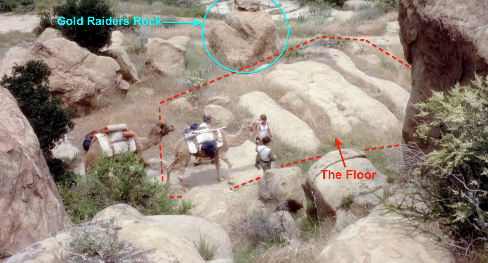
Here's one of the best views of the Floor that I've seen in any production. This view from high above Wrench Rock appears in the movie "The Tomb," a Fred Olen Ray film about an Egyptian curse with a cast that included John Carradine, Sybil Danning and Cameron Mitchell. It was one of the later films shot on this part of the Iverson Movie Ranch, and as you can see, the producers brought a couple of camels to the site for the shoot.

In this version of the photo from "The Tomb" I've identified the area I call the Floor, along with nearby Gold Raiders Rock, which is partially visible here. Please click here if you would like to see more photos from this unusual Upper Iverson shoot and learn more about "The Tomb" — including the Iverson location of the Tomb itself.

Back to that first "Tales of Wells Fargo" episode, this shot from the video clip above illustrates why the Reflecting Pool has that name, with the camera capturing a clear reflection of Wrench Rock in the pool.

The pool continues to be employed as a creative element as the sequence plays out. Here it conveys partial reflections of two of the bushwackers getting the drop on Chuck Connors. We also see Notch Rock directly above the head of one of the bad guys.

Chuck Connors in "Tales of Wells Fargo," with Wrench Rock in the background

The hat says "goofy Western sidekick" but the eyes say "bad intent." Connors plays an enigmatic character here — is he the naive rube Button Smith, or the notorious outlaw Pete Johnson? We get a tasty glimpse of both personas in his "Tales of Wells Fargo" appearance — and as anyone who ever saw "Nightmare in Badham County" can tell you, there was more to Chuck Connors than the upright citizen and loving dad he played on "The Rifleman."

Sunday, June 8, 2014

Bird's-eye view of Chatsworth, Calif., in the 1920s offers a glimpse at movie history in the northwest San Fernando Valley

Aerial photo of Chatsworth, Calif., circa 1920s

I found an old bird's-eye view of Chatsworth, Calif., at the library, and while it's low-res by today's Bing and Google Earth standards, it's an important shot from a film history standpoint. The photo provides insights into the area surrounding the Iverson Movie Ranch when it was first getting up to speed as a filming location back in the silent movie era. I recommend that you click on these photos to see larger versions of them.

This shot indicates where the Iverson Movie Ranch, divided into its upper and lower halves, fits into the landscape. The photo is not clear enough to provide a meaningful look at the Iverson Ranch itself, but it helps put the nearby hills, roads and other features in perspective. The undated photo appears to be from sometime in the 1920s.

Oat Mountain may be the most frequently seen background feature in productions filmed on the Iverson Movie Ranch. Also noted here are Stoney Point — a Chatsworth landmark next to Topanga Canyon Boulevard that today is a popular rock-climbing destination — and a portion of the Brandeis Ranch that I call Brandeis Plain, which is often visible in the background in productions shot on the Upper Iverson. The Brandeis property was located immediately to the west of the Upper Iverson, and to the south and west of the Brandeis Estate was another filming location, the Lazy A Ranch, which operated mainly in the late 1930s and early 1940s.

The most exciting discovery in the early photo is a road that is now known as Johnson Motorway or Johnson Mountain Way. These days the road, besides serving as a fire break, is part of a hiking loop that includes the Rocky Peak area to the west. But the photo reveals that it already existed as a relatively well-defined road as far back as the 1920s, suggesting that it would have been used as a route into and out of the northwestern corner of the San Fernando Valley. This route is not nearly as well-known as Santa Susana Pass Road, built in 1917, which connected — and still connects — the San Fernando Valley and Simi Valley. The Johnson Motorway route is also much less well-documented than the old stagecoach road, which is not seen in this shot but entered the San Fernando Valley below Santa Susana Pass Road.

The old road winding its way down the hill from the northwest connected up in those days with Mayan Drive, part of early planned development in the foothills. The Twin Lakes project never fully took off, and the Deerlake Highlands development farther up the hill was a complete bust, with the land remaining undeveloped for almost 100 years. Today a small residential area at the northern end of Topanga bears the name Twin Lakes, and Mayan Drive runs through the neighborhood, connecting the top of Topanga with the top of Canoga. This shot also points out the location of the old Mayan Gate that marked the entrance to Twin Lakes. The gate stood near the southeast corner of the Iverson Movie Ranch until the 1950s.

1929 aerial: Roads for the Deerlake Highlands project already in place

The Twin Lakes neighborhood was only a small part of the grand scheme that included the proposed Deerlake Highlands development, and for almost a century the hills above Twin Lakes remained marked with some of the proposed residential streets that were carved out for Deerlake Highlands in the 1920s — mostly for homes that were never built.
 
Entrance to the new "Deerlake Ranch" gated community

The land that was designated to become Deerlake Highlands all the way back in the 1920s did eventually get developed, but not until the 21st century. Today it is a gated community known as "Deerlake Ranch," which has no connection to the original project other than geographic proximity and the use of the name. This development is visible in the hills above Chatsworth, appearing as a mass of relatively uniform homes filling the hillside area to the west of similar developments in Porter Ranch.

The Mayan Gate, marking the entrance to the Twin Lakes development

The above view of the Mayan Gate looks south, and would be the view visitors would get when leaving the Twin Lakes area. I know of one occasion when the Mayan Gate appeared in an old movie — the James Cagney feature "White Heat," which I discussed in this earlier blog entry. Visible in the distance in this shot, framed by the gate, is the hill known today as Summit Ridge, to the south of Twin Lakes and the Iverson Ranch.
 
"Old Los Angeles" (Republic, 1948): Summit Ridge turns up in the background

Summit Ridge, which today is another gated community, appears in the backgrounds of many movies filmed on the Iverson Ranch. This shot from the Bill Elliott Western "Old Los Angeles" is taken looking south through the Iverson Gorge, with Nyoka Cliff looming large on the left side of the frame and Hawk Rock jutting above the ridgeline on the right.

The Deerlake Highlands and Twin Lakes area in 2014

Here's a modern aerial photo showing the area of the proposed Twin Lakes and Deerlake Highlands developments. The neighborhood now known as Twin Lakes, circled in yellow at the bottom of the photo, is filled with unique residential homes, a rare few of which date back to the original development. The original Mayan Drive still winds through the neighborhood. Meanwhile, many of the roads that were carved out in the 1920s for Deerlake Highlands remained etched into the hills above the northwest San Fernando Valley as of 2014 and can be seen toward the top of the photo. The original layout was later destroyed as part of grading for today's Deerlake Ranch.

One feature that can be easily matched up between the circa 1920s bird's-eye photo and productions shot on the Iverson Movie Ranch is a short section of road set against the hills to the north of the Upper Iverson. I have been calling this section "Road Up the Hill" in my research, but thanks to the old bird's-eye shot, I now know that it was part of that original road that extended far to the northwest — the same road now known as Johnson Motorway and used mainly for hiking.

"Go West, Young Lady" (1941) — Road Up the Hill

Here's an example of a movie appearance by Road Up the Hill, or Johnson Motorway, in Columbia's musical-comedy Western "Go West, Young Lady," which starred Glenn Ford, Penny Singleton and Ann Miller. This shot is taken on the Upper Iverson, and Road Up the Hill can be seen in the top right corner.

The Line of Trees divided the Upper Iverson Movie Ranch from the Brandeis Estate to the west, including the section of the estate property I call Brandeis Plain. Road Up the Hill can be seen in the backgrounds of countless chase sequences filmed on both the Upper Iverson and the Lazy A Ranch, adjacent to the Brandeis Ranch. In this shot, a stagecoach can be seen near the center of the frame, speeding across the Upper Iverson.

"Johnny Concho" (United Artists, 1956)

Here's another movie appearance by Road Up the Hill, in the Frank Sinatra Western "Johnny Concho." Road Up the Hill appears near the top left corner, and this shot also features Bear Tree — a photogenic Upper Iverson oak tree that survived well into the 21st century.

This is the same "Johnny Concho" shot, pointing out Road Up the Hill and Bear Tree. Bear Tree was discussed in detail in this earlier blog post.
 
Frank Sinatra and Phyllis Kirk at Corriganville in "Johnny Concho"

If you'd like to receive updates on the Iverson Movie Ranch and other old filming locations, please join the Iverson Movie Ranch Blog mailing list. Just send me a note at iversonfilmranch@aol.com and let me know you'd like to be added to the list.