Promo Still "A" for "Harum Scarum" (1965): Elvis Presley and Mary Ann Mobley
on the Iverson Movie Ranch
It took some doing, but we recently figured out the locations for two promotional stills for the Elvis movie "Harum Scarum." Both shots feature Elvis Presley and Mary Ann Mobley riding the Lower Iverson Movie Ranch.
Promo Still "B": Elvis and Mary Ann at Iverson
The photos, which I'm calling "Promo Still A" and "Promo Still B," were shot back-to-back and appear to be taken from the same location. Based on the "Harum Scarum" shooting schedule, which Elvis movie location expert Bill Bram shared with me, the photos would have been taken on Wednesday, March 17, 1965.
Elvis Presley and Fran Jeffries in Garden of the Gods
That's the same day Elvis was at Iverson to shoot the original version of the tent sequence, which I blogged about recently. You can
click here to read about this shoot, which took place in Garden of the Gods. Elvis appears to have spent just one day at Iverson during shooting on "Harum Scarum."
Let's look first at Promo Still A, which was apparently taken moments before Promo Still B. In this version of the shot I've highlighted a couple of the main features. The big clump of rocks that dominates the background is a part of Rock Island, seen from an angle that rarely turned up in the movies.
"Trailin' West" (1936) — the same corner of Rock Island
One of the few times that same clump did turn up was in the old Warner Bros. B-Western "Trailin' West," which gave me the clue I needed to find the location of Promo Still A. The big pile of rocks, located at the northwest corner of Rock Island, appears behind the stagecoach in this shot. The angle is slightly different, but readers may be able to see the similarities in the rocks in the above two photos.
"Trailin' West" — wider view
A wider view of the same area, from the same scene in "Trailin' West," helps pinpoint where the scene was filmed, Filling the left half of the screen is the same big rockpile seen in the Elvis photo, but the key to finding the site turns out to be the even larger pile of rocks that fills the right half of the frame.
The two main rock clumps in the "Trailin' West" photo are identified here. I'll go into detail below about the fate of Rock Island, but for now I want to focus on the rocks at the right of the shot — an area I call Batman Corner.
Batman Corner in 2014
This shot of Batman Corner was taken on a visit to the site late last year. Batman Corner — which is essentially the back side of
Batman Rock — is located today at the corner of Redmesa Road and Horizon Place.
Here's a side-by-side comparison of the shot from "Trailin' West" and the recent shot of Batman Corner, taken almost 80 years apart. I've highlighted the rounded top of the main rock, which is seen in both photos. From this angle it's impossible to tell that the rock is the same one we know as Batman Rock.
Batman Rock, as it appears today — the classic angle
If
we were to walk a short distance west from where the preceding shots were taken, we would see this more familiar side of the
distinctive rock known as Batman Rock. Some readers may recognize this
view of the rock from John Ford's "Stagecoach" and other
appearances in the movies and on TV.
"Batman and Robin" (Columbia serial, 1949)
The name "Batman Rock" comes from appearances in Columbia's Batman serials of the 1940s — "Batman" in 1943 and "Batman and Robin" in 1949 — which also inspired the popular "Batman" TV series of the 1960s.
A portion of the Lower Iverson (1952 aerial photo)
The
area where Promo Stills A and B were shot is seen in this aerial view
of a section of the Lower Iverson Movie Ranch from 1952, which I will
show again below with the specific sites identified. The 1952 aerial
photo is probably the sharpest aerial to surface so far that shows the
Iverson Ranch during the filming days.
One of the most important features of the aerial shot is the access road, which ran from the Iverson Movie Ranch entrance on Santa Susana Pass Road (not pictured) to the Iverson family residence. It was along this road that the Elvis promo shots were taken in 1965.
Taking another look at Promo Still B, I want to call your attention to the rock in the top left corner and the stone buttressing along the bottom of the photo.
"Harum Scarum": Doubles ride north through the Iverson Gorge
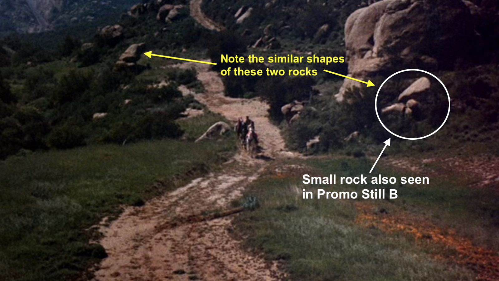
The small rock in Promo Still B can be seen again in this shot from "Harum Scarum," which pinpoints the location of the small rock near the northeast corner of Rock Island. It should be noted that unlike the promo stills, the actual movie shot has doubles filling in for the actors, so Elvis does not appear in this shot.
A number of features in the movie shot are noteworthy, and I've highlighted some of them here. You may want to click on these shots to see a larger version. In the movie shot the riders are following the Stagecoach Road, which runs more or less north and south through the Iverson Gorge and eventually meets up with the access road.
The key to pinpointing Promo Still B is the small rock near Rock Island, which appears in both the movie shot and the promo still. I wanted to point out the similarity in shape between Bald Knob and the smaller rock because I found it both intriguing and a little confusing. When I first began studying Promo Still B, I was thrown off because I thought the smaller rock was in fact Bald Knob. That sort of thing happens a lot.
Returning to the 1952 aerial photo, we can now add the Stagecoach Road to the equation.
We can also now zero in on approximately where the riders, played by doubles, appear in the movie shot.
While we're at it, I wanted to nail down where the buttressing area is along the access road. This is the area where the film studio's still photographer would have been positioned when he snapped Promo Stills A and B.
Now we're able to approximate the positions of Elvis Presley and Mary Ann Mobley in the two promotional shots.
Finally, we can translate the positions of Elvis and Mary Ann in the promo shots to the modern configuration of the terrain, which today is filled by the Cal West Townhomes. The location where the promo stills were shot is just north of the condo development's swimming pool area off Redmesa Road.
As for the clump of rocks seen in Promo Still A, which once stood tall at the northwest corner of Rock Island, it appears to remain at least partially intact. However, for a number of reasons it is all but impossible to see.
"Rock Island Prison" — current home to the big clump of rocks
Today the big rock clump is locked behind a fence as part of a swimming pool area for the condos. I've referred to this area in the past as "Rock Island Prison" — a prison of sorts for famous movie rocks.
Not much to see anymore of the big rockpile
This photo gives some idea of where the pile of rocks that graces the Elvis promo shot can be found today. These days it's possible to see just a fragment of the formation at its southern end, marked in blue here. We have no way to get a decent look at the north side of the pile — the part that's showcased in the Elvis shot.
The north end of the rock clump is in there somewhere
Being locked behind a fence and largely buried underground are among the rock clump's problems, but an even bigger problem, when it comes to trying to see the rocks, is that they are now covered with ivy.
Southeast corner of Rock Island — now contained within the walls of "Rock Island Prison"
I've blogged before about how the charismatic Eraserhead, which held down the southeast corner of Rock Island, was largely buried during grading for the condo development. (
Please click here for details about that.) Now it also appears that the northwest corner of Rock Island, years after its photo op with Elvis, suffered a similar fate.
Promo Still "B" from 1965
Taking another look at Promo Still B for "Harum Scarum," I want to point out that the stone buttressing seen in the foreground was already at least 30 years old when Elvis rode past it in 1965.
"The Miracle Rider" (1935) — same buttressing seen in Promo Still B
I know that because the same stone buttressing can be found in this shot from the 1935 Mascot serial "The Miracle Rider," starring Tom Mix. In this case the buttressing is seen from a much different angle, from the south.
Another shot from the same sequence in "The Miracle Rider" includes not only a portion of the buttressing, but also the same small rock north of Rock Island that appears in Promo Still B.
In other words, this shot from "The Miracle Rider" depicts the same little valley where Elvis and Mary Ann Mobley would be photographed on horseback 30 years later.
"Undercover Man" (Hopalong Cassidy, 1942)
I find the stone buttressing north of Rock Island to be one of the most fascinating, and least documented, features of the Iverson Gorge. One of the main reasons it's so fascinating is the same reason it's
not well-documented — simply because it no longer exists.
"Batman and Robin" (1949)
But as you can see in these photos, the buttressing did make it into its share of productions.
"Batman and Robin" — buttressing area shot from the opposite direction
In the Columbia serial "Batman and Robin," the same stretch of buttressed road was filmed from both directions.
Nyoka Cliff and the Stagecoach Road in recent years, with stone buttressing noted
I wish I could say some relic of that stretch of buttressing north of
Rock Island survived the condo development that began in the late 1980s,
but I've searched for it, and it's gone. Fortunately, other examples of
buttressing lower in the Gorge remain in place today, mainly in the area
below Lone Ranger Rock and Nyoka Cliff.
Another example of buttressing along the Stagecoach Road, Lower Gorge
The buttressing seen in this photo, taken on a visit to the Iverson Gorge in 2014, can be found just below Lone Ranger Rock.
Stone buttressing near Garden of the Gods — still in place today
Still another example of stone buttressing from Iverson's filming days turned up late last year near Garden of the Gods on an expedition by Iverson researcher Cliff Roberts. I blogged about this discovery a few months back, and
you can read that post — which includes directions to this movie relic — by clicking here.
By the way, if you know who Dick Foran is — his old B-Western "Trailin' West" is mentioned in this post — check out the above link to a cool new DVD set on Amazon — "Dick Foran Western Collection," part of the Warner Bros. Archive Collection. These are remastered versions of 12 Dick Foran Westerns in great picture quality. Besides "Trailin' West," the set includes the Iverson movies "Land Beyond the Law," "Blazing Sixes," "California Mail" and "Guns of the Pecos," and a bunch more.


%2B%26%2B2014-Batman%2BCorner-noted.png)