

The Upper Gorge has been the focus of some of the most challenging research into the history of the Iverson Movie Ranch, and during the past year we've been taking an especially intense look at the area.


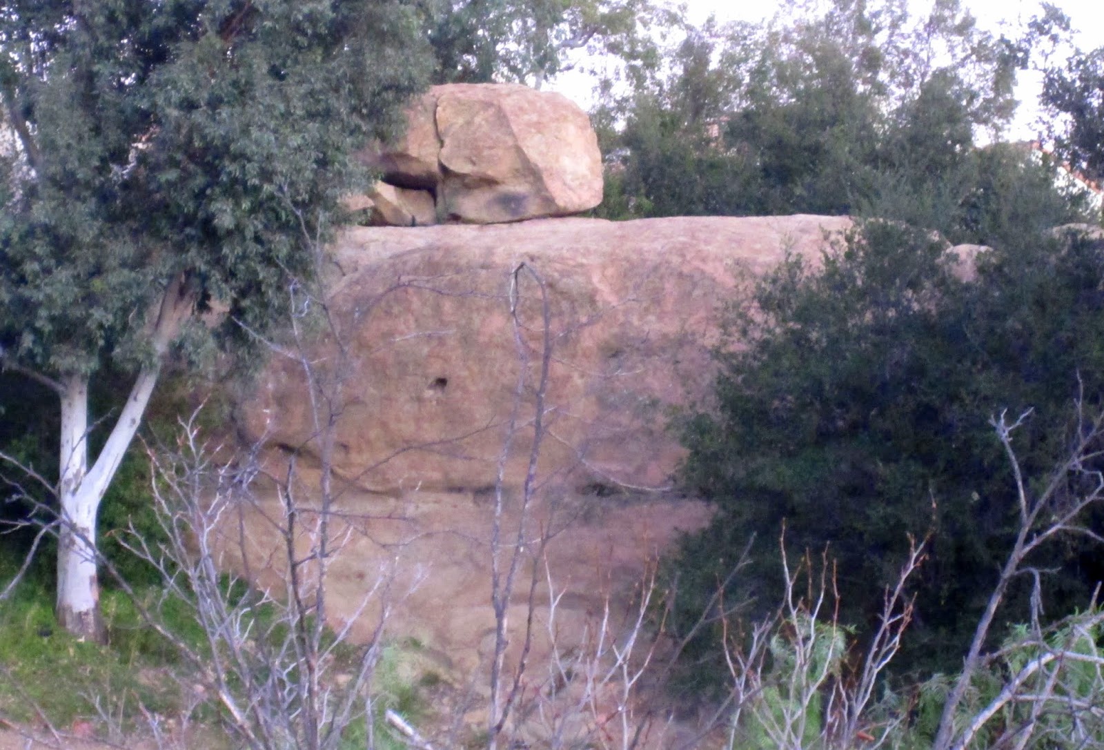
Fortifications built onto the tops of rocks
The massive rock features of the Upper Gorge were tranformed into a maze of crumbling walls and "stone" fortifications, with much of the set built high atop the site's natural sandstone features.


John Ford directs "Wee Willie Winkie" in 1937 (promo still)
A promotional still for the movie shows more of the gate and the main tower area, while also revealing a long set of steps descending from the gate down into the Gorge.


Promo still for "Wee Willie Winkie" (Jerry England collection)
A similar promo still offers an alternate view of the steps and other parts of the set. The photo is taken from almost the same angle as the previous promo shot, but the crew has cleared out, revealing more of the landscape.


The area above the stairway and north of the gate (behind-the-scenes photo)
This shot depicts the gate from the opposite side, looking south, with Wyatt Earp Rock right up next to it. We're fortunate in that a number of nice behind-the-scenes photos of the "Wee Willie Winkie" sets have surfaced.


Wyatt Earp and his brother take cover behind Wyatt Earp Rock (1960)
The origin of the rock name "Wyatt Earp Rock" has a lot to do with the TV series "The Life and Legend of Wyatt Earp." If you click here you'll find a post that sort of explains how things went down.


"The Lives of a Bengal Lancer" (1935): The main tower at "Mogala"
In "The Lives of a Bengal Lancer," the main tower in the movie's "Mogala" set stood between Lancer Arch and Wyatt Earp Rock — right in the middle of where the "Wee Willie Winkie" set would later stand.


Camel saddles on the "Wee Willie Winkie" set, 1937
A reference point in the "Wee Willie Winkie" set photo is this group of camel saddles parked on the set, awaiting their closeup. These saddles would get plenty of use in the movie.


"Wee Willie Winkie" set looking southwest
Another behind-the-scenes photo, looking southwest this time, ties together a number of the features seen in previous photos.


"Stagecoach" (1939): John Wayne's Ringo Kid arrives in the Iverson Gorge
Two years later, director John Ford would return to this spot for "Stagecoach." The iconic sequence introducing John Wayne's character, the Ringo Kid, includes this shot taken from almost the same angle.


"Tarzan the Ape Man" (1932): Tarzan and Jane head for those same steps
The same steps are seen in 1932, near the end of "Tarzan the Ape Man," as Johnny Weissmuller and Maureen O'Sullivan rush toward Three Ages Rock in one of the movie's closing shots.

Tarzan and Jane use the steps to climb to the top of Three Ages Rock
It's likely that the steps were put in place specifically for "Tarzan the Ape Man," although it's hard to be sure. We do know that the actors used the steps to get up on the rock.


The Tarzan and Jane rock today ("Three Ages Rock")
The rock on which Tarzan and Jane stood during this historic movie sequence can still be found today, and is readily identified by its large vertical crack. The steps they climbed, however, no longer exist.

The Upper Gorge as it appears today, in a Google Maps 3D image
When the Cal West Townhomes were built on the former movie ranch in the 1980s, some of the movie rocks of the Upper Gorge survived while others perished. The first two rows of condos are visible here above the Gorge.


The Iverson Movie Ranch's Upper Gorge (Google aerial)
Here's a satellite shot of the same area from directly overhead, highlighting what can be thought of as the "frontier" between the historic movie rocks to the south and the Cal West Townhomes to the north.

The same area before condo development (1971 aerial)
This is what the same area looked like before the condos were built. Taken at a time when filming at Iverson had all but shut down, the 1971 aerial provides one of the last good overviews of the original rock formations.

Footprint of the first two rows of condos, outlined in red
To get an idea of the impact condo development had on the Iverson Gorge, we can examine the footprint of the first two rows of condos.

The condo footprint superimposed over the 1971 landscape
The footprint translates roughly to what you see here in the 1971 aerial, when the rock features of the Upper Gorge were still intact.


Surviving movie rocks near the first two rows of condos
Just outside the condo footprint we find an abundance of movie rocks, some of which, notably Rock Island, have been partially buried. Others, such as Three Ages Rock and Crown Rock, have been "downsized."

The same surviving formations in the current layout
The contemporary aerial view of the condo footprint area reveals where the major surviving rock formations are positioned around the condos in the modern landscape.

Rock Island: Mostly buried, but still in place
We examined Rock Island in a recent post, which can be found here. Material on Lone Ranger Rock, Three Ages Rock, Crown Rock and Devil's Doorway can also be found by clicking on the links in this sentence.

The Iverson Gorge in 1971: Prepare to turn left
This version of the 1971 aerial shot offers a slightly better view of the rocks that would later fall within the condo footprint. I've also noted the "normal" orientation of the shot, with north on top.

Rotating the image 90 degrees: A "horizontal" view of the Upper Gorge
To examine the Gorge in detail it's helpful to rotate the image 90 degrees counterclockwise — in part because the 1971 aerial photo is in reality a bird's-eye view, taken at a slight angle looking east.

Bird's-eye view of Iverson's Upper Gorge in 1971
In the aerial views that follow, we will default to looking at the Gorge from this direction: west to east, with east on top. Keep in mind that you should be able to click on any of these photos to see a much larger version.

Behind-the-scenes photo of the "Wee Willie Winkie" Gorge set in 1937
Many of the same rocks seen in the 1971 aerial photo also appear in the behind-the-scenes photo from 1937, taken with the camera looking north. This is a wider version of the photo seen at the top of this post.


Sandstone soldiers, marching in formation
You'll notice that the rocks run parallel to each other. Because they're sedimentary, the rocks form in layers and therefore tend to line up — a process dating back to the Cretaceous period about 100 million years ago.


"Land Beyond the Law" (Warner Bros., 1937): Devil's Doorway (Jerry England Collection)
The most famous part of the rock formation is the "Devil's Doorway" itself, a rock arch that was seen in countless movies and television shows, often serving as the gateway to an outlaw hideout.

Devil's Doorway today
It's a little bit out of the way these days, but the look of the rock formation remains pretty much the same as what it looked like throughout the filming era. You can see more about Devil's Doorway here.

"Devil's Wall" (attached to Devil's Doorway): Another survivor
Less well-known than the rock arch is the attached rock wall, which I call "Devil's Wall."

"Oh, Susanna" (Republic, 1936): Devil's Wall
Devil's Wall, too, had its movie moments — here it is in the old Gene Autry B-Western "Oh, Susanna." Rock walls tend to all look the same, but you may be able to ID it by the small diagonal crack near the left end.

"The Life and Legend of Wyatt Earp" (1958)
A short distance south of Devil's Wall is Crown Rock, seen here in an episode of the "Wyatt Earp" TV series called "Four," which premiered near the end of the show's third season, on May 27, 1958.

Crown Rock in "Saga of the Viking Women" (1957)
Crown Rock pops up in movies and TV shows all the time. Here it is in Roger Corman's Iverson Movie Ranch masterpiece "The Saga of the Viking Women and Their Voyage to the Waters of the Great Sea Serpent."

"Have Gun Will Travel": Warriors lie in wait on top of Crown Rock
This shot from the TV series "Have Gun Will Travel" offers a close look at Crown Rock from the east.


Signs of a messy divorce
The most common view of Crown Rock today is looking north from the driveway, where one can't help but notice that the south face of the rock bears the scars of having had its better half chipped away.


"Tarzan the Ape Man" (MGM, 1932): The Wall
We talked a little bit about The Wall near the top of this post, but we hadn't yet seen it without movie sets in front of it. The above shot from "Tarzan the Ape Man" shows what The Wall looked like in all its glory.

Three Ages Rock: Another rock wall once located near "The Wall" and "Devil's Wall"
A third rock wall, Three Ages Rock, can also be found in the same area. The proliferation of rock walls is attributable to their sedimentary origins, as is their inclination to all point in the same direction.


G1 through G5 in 1937
Three Ages Rock and Wyatt Earp Rock are both "players" in the lineup of five prominent parallel rocks we keep referring back to, G1 through G5.

Promo still for "Wee Willie Winkie" (1937)
Three Ages Rock and Wyatt Earp Rock are also key players in much of the construction and filming that took place in the Gorge in the 1930s, some of which we've discussed higher up in this post.

Promo still of the "Wee Willie Winkie" staircase area
I found another promo still of the "Wee Willie Winkie" set taken from a similar angle, and this one's colorized. The colorizing is a little weird, but the photo provides another interesting view of the area's rock features.


The curved rock in 2016
I spotted that same curved rock on an expedition into the Gorge a few years ago. The terrain is radically changed since the filming era, and nowadays the area is riddled with poison oak, rattlesnakes and other hazards.


The same hole in 2016
I happened to snap a photo of the hole on that same expedition into the Gorge in 2016.


Three Ages Rock in modern times
Today the tube marks the spot where the northernmost section of Three Ages Rock was removed to make way for condo construction.


Set for "Flight Into Nowhere" (1938): Behind-the-scenes photo
It's a little hard to recognize here, but G3 figured prominently in a shoot for the movie "Flight Into Nowhere," which I blogged about in October 2018. (Click here to see that post.)


An actual camel toe — the origin of the term (Get your mind out of the gutter!)
In this case the use of the term "camel toe" has nothing to do with Miley Cyrus or her "Wrecking Ball" video. It's more about what you see here, which is an actual camel toe ... and the rock's uncanny resemblance to it.

A "G-rated" alternative identifier
If modesty still prevents you from appreciating the "camel toe" references, here's an alternative that, while less colorful, will also suffice. The small horizontal depression reminds me of the destination sign on the front of a bus.


"Marshal of Heldorado" (1950): Gorge Arch, on the right
You may be familiar with a rock feature of the Upper Gorge known as the Gorge Arch, which can be seen at the right of the frame in this promo still for the B-Western "Marshal of Heldorado."

"The Silent Man" (Famous Players Lasky, 1917): Gorge Arch
The use of the Gorge Arch in movies goes back to the earliest days of filming on the Iverson Ranch. Here's a shot of the rock feature from more than 100 years ago, in the 1917 William S. Hart silent Western "The Silent Man."

"King of the Jungle" (filmed in 1932, released in 1933)
We get another good look at the Gorge Arch in this lobby card for the Buster Crabbe movie "King of the Jungle," filmed on the Iverson Movie Ranch in 1932.


Counting bodies in the Upper Gorge
Summing up the devastation that was unleashed upon rocks G1 through G5, we see that only a section of Three Ages Rock survived.

Gorge Cabin and Gorge Arch in a promo still from the early 1940s
Since we've been discussing the Gorge Arch it's worth also mentioning the Gorge Cabin, which stood near the arch from 1938-1944.


Former Gorge Cabin location (1971 aerial)
With the location of the Gorge Arch pinpointed, we can also note with some degree of accuracy where the Gorge Cabin stood — and we can see that it, too, was within the footprint of the condo complex.


Since much of what we've explored in this post is based on the Shirley Temple movie "Wee Willie Winkie," I thought it might be fun to see a clip of young Shirley out among the rocks in 1937 — check it out ...
Until you hit the 4:48 mark there's not much in the way of rocks, as it's mostly dialogue — mainly between Shirley Temple and Cesar Romero. But from 4:48 on, the clip pays off in glorious Iverson Gorge sets and scenery.

Good luck moving that rock, gents!
Did you notice the amusing shot at 5:55? Khan's men use "levers" to try to pry loose the main boulder on top of Three Ages Rock to use it to crush their enemy — as if those twigs could budge that monster!

This post is the third in a series of posts published since May 2018 that take a deep dive into the Iverson Gorge, which I've long considered the most challenging section of the former Iverson Ranch to research.

Previous posts examining the Gorge have focused on the 1935 movie "The Lives of a Bengal Lancer" and the 1938 movie "Flight Into Nowhere." Please click on the links in the previous sentence to see those posts, and click on the links below to go to Amazon to buy DVDs of some of the most important Iverson Gorge movies.
4 comments:
Wow what a post, you've outdone yourself on this one. This brings a lot of things into focus for me on the rocks that are lost forever. Thanks again for the hard work..
This was the one I was waiting for! I wanted to see some before and after overlays of the condo project and I got my wish in spades with this one! Thanks for all your effort...Greatjob!
Fascinating post. It's hard to see from the Google Maps view but were these rocks actually destroyed or were they mostly buried? It looks like the ground level is higher around the condos. It seems like a lot of rock to blast away to build a few houses!
Thanks for this :)
watch hd movies
Post a Comment