Promo still of Lillian Gish and unknown actor, circa 1915-1917 (Bison Archives)
A mysterious promotional photo from early in Hollywood's silent movie era has had film historians stumped for a while, but just in the past few weeks some of the photo's biggest mysteries have been solved.
The photo, which features Lillian Gish with an actor who has yet to be identified, dates from circa 1915-1917 and is thought to be associated with the Triangle Film Corp. — the D.W. Griffith-Thomas Ince-Mack Sennett partnership.
My hunch is that the actor in the shot is Wilfred Lucas, which would suggest the photo was taken for the 1917 feature "Souls Triumphant." At this point it's only a theory, and I would love to hear what readers think.
As soon as I received the photo I began trying to determine where it was taken. I concentrated initially on the bluffs in the background, which I thought almost "had to be" somewhere in the hills west of Chatsworth, Calif.
Zoomed-in shot of the background bluffs
This is what I was looking for, and it only took a couple of expeditions to the "edge of civilization" — along the perimeter of Chatsworth at the far west end of the San Fernando Valley — before it turned up.
The same bluffs as they appear today
The sandstone outcroppings were located on the side of an east-facing slope a short distance southwest of the Iverson Movie Ranch.
The key to identifying the rocks was this "face," which appears when the outcroppings are captured in the right light. To me it bears a strong resemblance to an Egyptian mummy.
The same "mummy-faced" rock can be seen in the background of the Lillian Gish photo.
The Kestrel, west of Chatsworth
The formation with the mummy-like rock is part of a section of the Santa Susana Mountains known as "The Kestrel." The formation was recognized by the both the Native American inhabitants of the region and early Spanish settlers, and has also been called "Gavilan" or "the Hawk."
In this recent shot of the formation, which I previously referred to in my own research as the "Bat Signal," the "mummy-faced" rock appears at the right of the frame.
The real Bat Signal
My old research name "Bat Signal" came from the formation's similarity to the actual Bat Signal from the "Batman" TV show — not that "actual" or "real" are the right words to use when describing the Bat Signal.
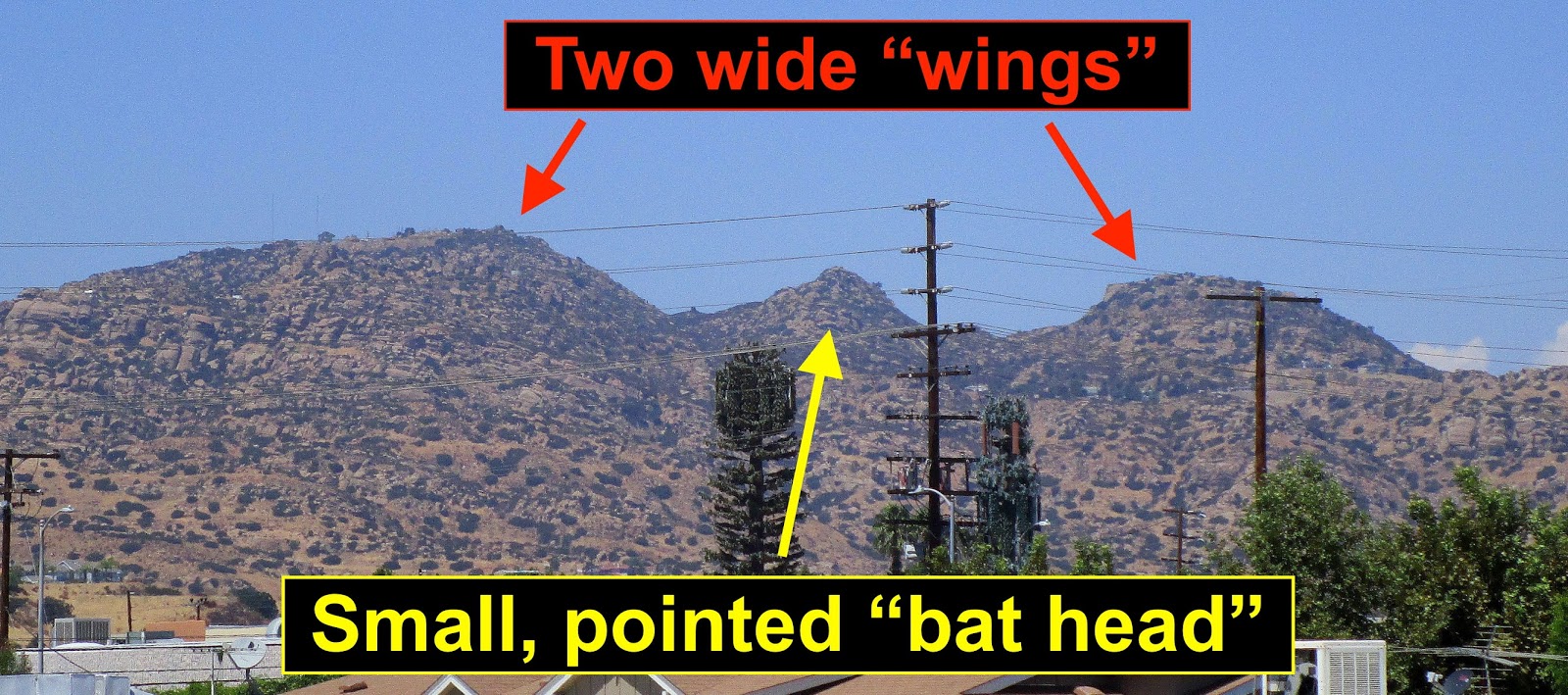
As usual with rock names, "Bat Signal" was not a perfect fit. But the formation's wide "wings" combined with the small peak in the center evoked the Bat Signal for me, and that's what I called it for years — until I learned something about the formation's history and realized that it had several more legitimate names.
An actual kestrel
The name "Kestrel" is an English translation from the Native Americans who were here for thousands of years. I'd say they got it right. Even though I came up with my own silly 21st century variation in the "Bat Signal," I feel a certain kinship with the region's early residents who also saw the rock formation's "head" and "wings."
The Kestrel in 1949
The Kestrel is visible across a wide swath of the northern San Fernando Valley. Here's a shot of it that someone posted online that was taken following a rare San Fernando Valley snowstorm on Jan. 11, 1949.
The photo is taken looking west along Plummer Street in Chatsworth. In my experience, once you see the Kestrel, it's impossible to "unsee" it. I apologize to those of you who might find this unsettling.
Promo still for "Three Word Brand," 1921 (Jerry England collection)
The Kestrel can occasionally be spotted in productions. Here's a promo shot for the silent William S. Hart Western "Three Word Brand," taken at the Chatsworth Reservoir, in which the Kestrel can be seen at the right.
The formation looks a little less "kestrel-like" from this angle — and even less "bat-like" — with the photo taken from farther south than the Lillian Gish promo still. But the profile of the formation remains recognizable.
"Bat Masterson" episode "Garrison Finish" (premiered Dec. 10, 1959)
In this screen shot from, appropriately, the TV show "Bat Masterson," a partial version of the Kestrel appears at top left, helping to pinpoint the filming location as the Marwyck Ranch in Northridge.
Marwyck was a thoroughbred farm founded by Barbara Stanwyck and Zeppo Marx, who owned neighboring ranches near Devonshire and Reseda. Stanwyck's home remains intact and is now known as the Oakridge Estate.
Extending north from the Kestrel are the same Santa Susana Mountains frequently seen in the backgrounds of productions filmed on the Iverson Ranch, although the unusual angle here makes them harder to recognize.
The Oakridge Estate — former home of Barbara Stanwyck
The Friends of Oakridge have been working for years to help preserve Stanwyck's Northridge home. I recommend a visit to
the website (click here) to learn more about the estate and its preservation.
Google aerial photo of northwest Chatsworth, including the Kestrel
It can be challenging to translate hill profiles to an aerial map, but here's a rough diagram. The tops of the Kestrel formation rise above Lilac Lane and Mesa Drive, east of Box Canyon Road.
You can barely see it here, but this is where Mummy Face can be found. Along with the bulk of the Kestrel, Mummy Face sits on land that today is part of the Santa Susana Pass State Historic Park.
Here's a zoomed-in version, just to give you an idea of what Mummy Face looks like in the aerial photo. I'm tempted to call it Max Headroom from this angle, but I will resist that temptation.
Other important features in the area include the Oakwood Memorial Park and the former Iverson Movie Ranch.
Once I determined the general location where the Lillian Gish photo was shot, I set my sights on finding the clump of rocks that stood behind Gish during the shoot.
"Search area" for the Lillian Gish rocks
With all the development that has taken place in the area since the 1910s, I felt it was likely that the rocks did not survive. And even if they had, there was still the pesky problem of finding them.
Ground Zero for the search
Thanks to getting a pretty good matching angle on the "Mummy Face" rock in the background, I was able to establish that Ground Zero for the search was somewhere near the Lassen-Andora intersection.
It's an interesting section of Chatsworth — not only a point where four roads meet, but also a frontier between the developed areas to the south, east and north and the undeveloped parkland to the west.
A number of landmarks can be found near this key intersection — including the Andora trailhead into the park, which is right where Roy Rogers and Dale Evans used to have their driveway.
Survivors: the same rocks seen in the Lillian Gish photo
Now we can add another landmark to the list: The Lillian Gish Rocks. They survived development, and can be found along the west side of Baden Avenue, just below Lassen and the cemetery entrance.
The rocks seen behind Lillian Gish are part of a larger cluster of rocks, most of which do not appear in the old promo shot. As you can see, today the rocks are behind a chain-link fence.
The "Lillian Gish Rocks" in 2020 (photo by Jerry Condit)
If you're able to resolve the logistics of the fence you can get a much better look at the rocks — something my buddy Jerry Condit succeeded in doing in early 2020.
While the rocks are on Baden Avenue, they're in the backyard of a house on Andora. The location of the rocks turned out to be pretty much at Ground Zero.
Once I found the Lillian Gish rocks I got a little cocky, setting my sights on the seemingly unrealistic goal of finding other features hidden deep within the promo shot.
Zoomed-in shot of the background features
Specifically, I wondered whether the old house seen in the circa 1915 photo might, by some miracle, still be standing. And assuming the house was long gone, I could still search for that interesting clump of rocks.
Undated photo of the Miranda Adobe in modern times
To my amazement, I found out the house is in fact still standing. Known today as the Miranda Adobe, the building was once the home of Francisco Miranda, an early Chatsworth homesteader.
A map of the old homesteads in the area shows that Miranda owned much of the property that became the Oakwood Memorial Park, along with a strip of land to the west that is now public parkland.
When the Oakwood Memorial Park was established at the west end of Lassen back in the early 1920s, Miranda's former home became a part of the cemetery.
The Miranda Adobe in 2017 — as Joan's Flowers
In recent years, the Miranda Adobe, now located behind the Oakwood offices and chapel, became a flower shop.
The building has been renovated and reinforced, but still retains much of its original appearance.
Out behind the flower shop, Mummy Face continues to overlook the setting.
The Miranda Adobe, circa 1915-1917, as seen in the Lillian Gish photo
Photos of the Miranda Adobe as far back as the 1910s are extremely rare. The Lillian Gish photo provides an important view of the building in its early setting.
But what about that great clump of rocks out behind the house?
The rocks out behind the Miranda Adobe
Sure enough, the rocks have survived too. They can still be found on a rise just north of the house.
Off the Beaten Path is a series of posts that stray from the usual subject matter of this blog, which is the Iverson Movie
Ranch. Past subjects have included Franklin Canyon, Bell Ranch, Pioneertown, Corriganville, Oak Park and other old filming locations. You can go directly to the Off the Beaten Path posts by looking
up the term "Off the Beaten Path" in the long index of labels at the right of the page, or by
clicking here.


11 comments:
Amazing research!!
Thanks, PD ...
I had a lot of fun with it. I wish they all turned out this well.
-SN
THX, like you I treasure the movie site locations.....
As a kid in Henrietta Ok. I saw every western movie and every RR & GA t.v. shows. I always wondered about these rocks - as I could see in many movie.
es that the same one's were used for background.
Nicely done!
Wow! Very, very impressive detective work. Well done.
Well done, thank you for some more great history
Once again you've shown you are a formidable foe! I Love this Blog!
Thanks for all the great feedback.
Stephen asked about what appears to be another structure farther back, beyond the row of rocks. I believe it was a secondary building that was part of the Miranda homestead, like a garage, a small barn or a shed. It did not survive. If you go past the row of rocks, everything has been developed, and in fact there's some development going on in that corner of the cemetery even now. That building appears to have gone away some time ago.
There's another old building that was taken down just in the past few years. It isn't visible in the Lillian Gish photo, because it would have been behind the house (if it was standing at that time). But you can find the building on Bing maps, which are a little bit older than Google maps. On the current Google map, the building is gone.
You can see it in the blog post if you look hard enough. Click on one of the photos to get a larger version, and in that view you should also get a message telling you which number photo you're looking at. If you look at photo number 26 (of 44), that's a Bing bird's-eye, and if you can figure out how to zoom in you should be able to find it. (One way would be to download it and then use your zoom function on whatever photo viewer you have on your computer -- or else just go to Bing maps instead, where you would be able to see a much clearer version.) Look for a large white rectangular building, just inside the cemetery property (west of the chapel, which is north of the administration building, which is just inside the gate). Just below this large white rectangular building is a tiny structure, and if you look at the same spot on the Google aerial (you would have to go to Google Maps, as I don't have a suitable example in the post), you'll see that the building is gone now.
I know this is more detailed than most people want, which is why I didn't get into it in the original post. But it is a good question, and I was kind of wondering whether anyone would ask about that building. The relatively recent disappearance of the other building (the one below the white rectangular building) is also interesting, because it serves as a reminder that the need to preserve our history is an ongoing battle.
Thanks for caring!
-SN
Great job! I will check the rocks out on the way to re-opened Chatsworth Park South... someday...
OH MY GOSH you outdid yourself on this one. I spent half an hour perusing the Stanwyck home website alone….your research is priceless. And that adobe is so historical - I am glad it is still standing even if as a flower shop. Amazing work…keep it up…I get antsy if you don't post after a few weeks I'm addicted to this blog! Thanks for your work!
PS: I googled Francisco Miranda. This came up… https://image.slidesharecdn.com/chatsworthhillshomesteaderspart2rev2014-5-2-141007154654-conversion-gate01/95/chatsworth-homesteaders-part-2-california-10-638.jpg?cb=1452146651
Francisco Miranda • Francisco was born in 1846 in Sonora, Mexico. His father Francesco was born in 1788 in Spain. • His wife Maria Antonia Salas was born in 1856 in San Juan Batista, Monterey California, as was her mother. The San Juan Batista Mission (1797) is next to the Monterey Presidio (1770 Spanish fort). • Maria Antonia Miranda was descended from one of the families that came with the second Anza Expedition in 1775. Her ancestor gave birth along the trail on Dec. 24th, 1775. 1/6/2016 Chatsworth Historical Society - Chatsworth Hills Homesteaders Part 2 10 William H. Miranda and wife Irene Lyon. This photo was taken about 1918-1919 in Chatsworth. He worked on the Iverson Ranch about this time. He served in WWII and died in the Sylmar VA hospital collapse in the 1971 earthquake.
Post a Comment