
Interactive map of the Iverson Movie Ranch and nearby filming locations
Movie location explorer Tyler Malone has created a map of famous rocks and filming sites on the Iverson Movie Ranch. You can see the Lower Iverson above, with each of the blue "tags" pointing to a movie rock.

It's interactive!
The map is interactive, so you should be able to click on individual tags to see details about particular rock features. You can also zoom in and out, or use your mouse to "drag" the map to move it around.


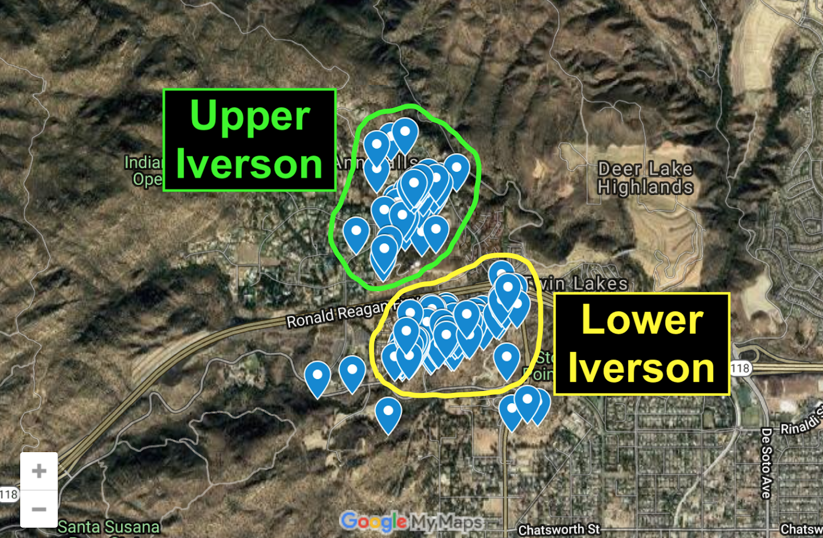
Zoom out to see the Upper and Lower Iverson combined
If you zoom out (by using the "minus" button), you can see both the Upper Iverson and the Lower Iverson.

Wide map of Santa Susana Mountains filming locations
If you zoom out even further, you'll see that Tyler's map extends to a few other locations in the Santa Susana Mountains, including Corriganville to the east and various Chatsworth filming sites southwest of the Iverson Ranch.

Three major filming areas in the Santa Susana Mountains
In addition to the two most heavily filmed movie ranches of all time — the Iverson Ranch and Corriganville — the map points the way to some fascinating and lesser-known Chatsworth filming sites, inside the green circle.

Zooming in on the Gorge, on the Lower Iverson
Here's an example of what the map looks like when you zoom in on a particular area — in this case we're seeing a section of the Upper Gorge below the condos on the Lower Iverson, along the eastern edge of Redmesa Road.

Interactive tag for "The Pit"
Tyler set up the map to interact with the Iverson Movie Ranch Blog, so if you click on a tag — for example, the tag noted here for "The Pit" — it brings up information from the blog, usually including a link.

Side panel with details about "The Pit"
Clicking on the tag for the Pit brings up a side panel containing a photo, the feature's name and a link to a blog post about the Pit. Again, this will only work on the interactive version of the map, found at the top of this post.

Blog post about "The Pit," found by following the link in the side panel
You can click on the link in the side panel, which will take you to a blog post about the specific feature tagged on the interactive map. For example, the link associated with the Pit takes you to this post from 2018.

Tyler Malone, in white Range Rover, re-creates "Bad Day at Black Rock" in the Alabama Hills
Tyler Malone, who created the interactive Iverson map, has been exploring filming locations for years, and often takes "then and now" shots in which he re-enacts scenes from the movies.

Monument Valley's John Ford Point: Tyler vs. "The Searchers"

"The Duel at Silver Creek" (1952): The Lower Iverson, then and now
Tyler recently began focusing increasingly on the Iverson Movie Ranch. That's Tyler in the bottom photo, in the black T-shirt, walking toward a distinctive Lower Iverson rock formation seen in "The Duel at Silver Creek."

The same rock, on the interactive map
The rock from "The Duel at Silver Creek" can also be found on Tyler's map, due east of the easternmost condo unit on the former Lower Iverson. Today the rock is on private property in an area that is inaccessible.

"Bat Masterson" TV episode "Buffalo Kill" (1959): a hard-to-find rock
Tyler has also been helping me locate mystery rocks on the Iverson Ranch, and has already made some key finds. Longtime readers may recall the above photo, part of a 2017 post about "unsolved mysteries."

The same rock today, largely concealed behind foliage
The rock today is hidden behind brush in an out-of-the-way spot along the northwest slope of Cactus Hill, and is almost impossible to recognize. Tyler pulled off a small miracle by tracking it down.

Up close with the business end of the rock, now known as "Buffalo Kill Rock"
We visited the rock in July to make sure we were seeing what we thought we were seeing, and everything checked out. In honor of the "Bat Masterson" episode, we've taken to calling this unusual rock feature "Buffalo Kill Rock."


Buffalo Kill Rock on the Iverson Ranch map (go to the top of this post for interactive features)
Buffalo Kill Rock can be found on Tyler's map, but as you can see, we don't have much info on it yet. The map remains a work in progress, and will probably soon link to the blog post you're now reading.

Buffalo Kill Rock's location on Cactus Hill
It's impossible today to duplicate Buffalo Kill Rock's distinctive "sub sandwich" appearance from "Bat Masterson," but thanks to Tyler's map it's relatively easy to pinpoint the rock's location: northwest of the water tanks.

"Excuse Me" (1925): Norma Shearer-Conrad Nagel movie filmed at Iverson
Another Iverson mystery rock Tyler found appears in the Norma Shearer silent movie "Excuse Me." The movie itself is hard to find, to put it mildly, but a couple of interesting promo stills have turned up.

Promo still for "Excuse Me": Norma sits on the Norma Shearer Rocks
I first blogged about "Excuse Me" in December 2018 as part of a post about promo stills that found their way to me from Marc Wanamaker's Bison Archives. Click here to see the post, and scroll down to the "Excuse Me" part.

The Norma Shearer Rocks today, in Iverson's Garden of the Gods
At the time I was still looking for the "Norma Shearer Rocks," where the actress sat during the filming of "Excuse Me." I found them a few weeks later, and published a blog item about them that you can see by clicking here.

"Excuse Me" promo still: Norma Shearer climbs "Excuse Me Point"
Another promo still for "Excuse Me" had Norma on top of a pointed rock that proved much more difficult to find. I mentioned in my first post about "Excuse Me" that I was looking for this one.

"Excuse Me Point": The same rock Norma Shearer ascended in 1925
Tyler took me up on the challenge, and to both of our surprise, he found "Excuse Me Point." Perhaps even moreso than in the case of Buffalo Kill Rock, it was a miracle that he ever found this rock.

"Excuse Me Point": Part of a jumbled pile of rarely filmed rocks
"Excuse Me Point" is buried in the deep recesses of the rarely filmed Western Garden of the Gods. To make matters worse, the rocks have shifted considerably in the almost 100 years since Norma Shearer dropped by.


Excuse Me Point can be found on the interactive map, where it's one of the southernmost features noted in the Garden of the Gods. Go to the interactive version of the map at the top of this post to check it out.
Tyler Malone's interactive map of Chatsworth-area filming locations
Tyler's interactive map is an impressive achievement — I know readers of this blog will have fun with it. If you're having trouble accessing the interactive features, try clicking here to go to the map's homepage.

Tyler Malone, in blue shirt, gets his "Jurassic Park" on at Red Rock Canyon
I want to send out a big thank-you to Tyler for the incredible map, for your enthusiasm and your help finding tough movie rocks, and for all of your outstanding contributions to film history. I look forward to future adventures.
10 comments:
Thanks, Dennis. It was a pleasure to map out all these film locations of important historical and cultural value from your blog and to help you find a few more. Cheers!
Wonderful, Wonderful!!! This is a terrific orientation aid. The links make it so educational too. Thank you.
Absolutely Fabulous! Really appreciate your effort and talent in producing this map!
Thank you Dennis for another excellent view into the Iverson Movie Ranch. Tyler's interactive map is fantastic!
great work dennis and tyler.it's great to see where all the movie rocks are so close to each other.the map really shows it all.does tyler have his own blog about movie loctions.thanks again for the good work.
stephen
Wow! Fabulous post...thanks to both of you!
The new map from Tyler is fantastic. A wonderful addition to your website and all of your great research. It really helps to put it all together.
Dennis and Tyler here’s a BIG THANK YOU for all your passion and hard work. Yesterday we spent 4 hours in the Garden of the Gods creating Then and Now photos. What a BLAST. I live in Newbury Park so we’ll be out exploring frequently. Many thanks, Kristine.
Hi, great work! For the record, we shot a lot of scenes at THE HANGOVER rock in 2019 & 2020 for The Babysitter: Killer Queen. I was aware of the area we were in but not the exact film(s) history - lovely to discover.
Wow, that's quite a shoot. Thanks for the heads-up, Bruce. I think your "blood on the rocks" quotient might be higher than that of all of the Iverson B-Westerns combined.
Filming in the Hangover Rock area goes back to the silent movies — at least as far back as "Three Ages" in 1923 and "Pony Express" in 1925. And it's one of the few areas of the former location ranch that remain active today. It's where they shot the "Jungle Book" sequel "Mowgli's Story" in 1997 and the NBC series "Heroes" in 2008, and it still turns up in car commercials once in a while.
I noticed you even caught a little bit of the "Peach Slice" in one of your shots for "Killer Queen." Kind of a funny little rock — you can find it in the index on the right.
I'm always eager to hear about later shoots on the former Iverson Movie Ranch. Please let us know if you're aware of any others. They're harder to track down than one would think.
Thanks again!
-SN
Post a Comment