

If you ever find yourself driving through Westlake Village on the 101, take a moment to ponder the movie and TV history of the majestic Simi Ridge.

You should have plenty of time for quiet reflection, since the freeway was designed to bear about one-tenth of the traffic it carries today and there's a good chance you'll be bogged down in a bumper-to-bumper quagmire.

You might even want to tear yourself away from the grind for a half-hour or so. As you pull off the freeway at Lindero Canyon Road and drive north, one of the best-kept secrets of the TV Westerns unfolds before your eyes.

"Gunsmoke" filmed in the area for about 15 years — longer than any other show. But many other TV Westerns, including "The Virginian," "The Big Valley" and "Wanted Dead or Alive," also worked the Simi Ridge.

The movies got in on the act, too. Here's a behind-the-scenes photo taken during filming on the William Holden-Richard Widmark Western "Alvarez Kelly," with the Simi Ridge once again looming in the background.


While the iconic ridgeline came to be a symbol of the American West as it was depicted on TV, some of the most interesting shoots played out in the nooks and crannies hidden below.

In contrast to the pastoral lowlands and rolling hills that define much of the Conejo Valley, the landscape in this corner of the valley is populated by striking rock features.

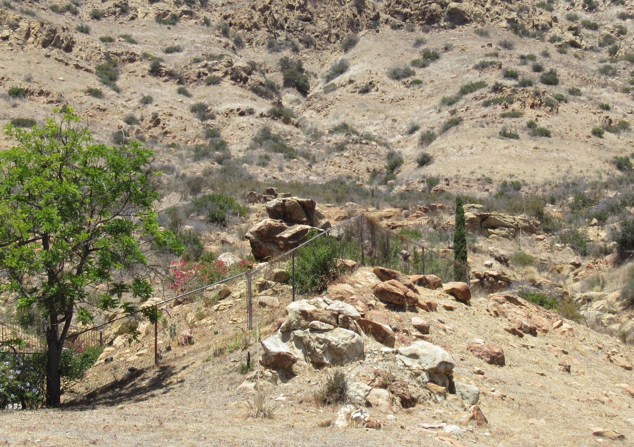
Many of these rocks can still be found at the site today. This one was hard to locate and even harder to get to, but once I found my way there I was able to capture something close to the "Gunsmoke" angle.

I've taken to calling it "Blocker Rock" in honor of its featured role in "Abe Blocker" — and it doesn't hurt that the rock is basically a giant brick-shaped block of sandstone.

All of the smaller rocks once perched tenuously atop the mothership, whether they were real or fake, also rumbled off into the abyss long ago — hardly a surprise given the precarious tilt of the base rock.

Here's a wider shot of Blocker Rock showing some of the contemporary landscape around the rock. It's not exactly a user-friendly environment.

By shifting the angle, we can get a look at some of the rocks positioned on the ridge north of Blocker Rock.

In particular, note the unusual rock pillar up on the ridge, circled in yellow.

This rock pillar also appears in some "Gunsmoke" episodes. Here it is at top left, along with Blocker Rock at top right, in the season 11 episode "South Wind."

Other rocks in the "South Wind" screen shot can also be identified in the current landscape. As an example, note the small rock circled here in blue, just below Blocker Rock.

The same small rock remains easy to identify in 2021, and even has some unusual markings on it. Other rocks in the vicinity can be similarly matched up, although it can be a challenge.

Most of the rocky action in "Gunsmoke" that wasn't shot on the Iverson Movie Ranch was filmed in Upper Lindero Canyon, in proximity to what today are residential cul de sacs in a far corner of Westlake Village.

Here's a wider view of Upper Lindero Canyon, home to suburban North Ranch. Today it's a relatively upscale section of Westlake Village, but back in the '60s the biggest thing going on in the canyon was "Gunsmoke."

The "Gunsmoke" hot spot is tucked away at the extreme northeast end of Westlake Village. The long-running TV Western shot close to 20 episodes in this location, which at the time was part of the Albertson Ranch.

Both the Albertson Ranch and the neighboring Agoura Ranch to the east were working ranches, and the fence that separated them would occasionally find its way into productions.

"Gunsmoke" had a long-term deal to film on the Albertson Ranch, and other shows would follow. But plans to develop the Albertson Ranch into Westlake Village would put a stop to filming by the end of the 1970s.

This is a recent shot of the same spot where Dillon walked. Today a house sits on the Oak Park side, while the foreground is all part of a barren "no man's land" between Oak Park and Westlake Village.

Today most of the fences in the area designate residential property lines, but remnants of the old fence can still be found, barbed wire and all, still marking the old ranch boundary.

The fence is showing signs of wear and tear, including burned posts that I have to think owe their current condition to the Woolsey Fire back in 2018. Evidence of Woolsey's devastation can be seen throughout the area.

You may have noticed something that looks almost like a scar — a straight line running southwest to northeast across the map of North Ranch. This is the Lindero, where the fence ran that once separated the two ranches.

When you drive in from the south on Lindero Canyon Road, you're driving along this historic boundary line. In fact, the road's name, "lindero," is a Spanish word that translates in English to "boundary."

Along with cattle and other traditional ranching activities, both the Agoura Ranch and the Albertson Ranch maintained major filming operations for decades, as did the Janss Conejo Ranch a little farther west.

Today the Lindero stands as both a historical boundary and a modern municipal one. The modern boundary line separates unincorporated Oak Park to the east from the community of Westlake Village on the west side.

From the location where Matt was seen walking near the fence, we still have to make our way farther up the hill to reach the area where most of the "Gunsmoke" rocks can be found.
 It's a bit of a climb
There's a hiking trail to help you get there, but as you might be able to tell, it's all uphill.
 "Abe Blocker" (1962) — One of the best "Gunsmoke" episodes for Simi Ridge rocks
I like to think about what it must have been like for the "Gunsmoke" crew to arrive in this picturesque spot back before all the houses, power poles and other signs of "progress" started chipping away at the view.
 "Monkey Rock," above Smokey Ridge and Golden Sky Circle
One of the first things the crew would have spotted is this rock, one of the most prominent features of the landscape. Known to some local residents as "Monkey Rock," it would become a familiar sight in "Gunsmoke."
 "Double Entry" (1965): The stage arrives below Monkey Rock
Here's a little better look at Monkey Rock, at top right. It wouldn't be possible to get this shot today because the open area below Monkey Rock is now filled with suburban homes.
 Monkey Rock, center, in its current environs
This photo from a recent visit to the site gives an idea of how Monkey Rock coexists today with the homes, power lines and other amenities of the contemporary landscape — along with the Simi Ridge towering behind it.
 "Double Entry" — Monkey Rock in action
Monkey Rock provides the focal point for an action sequence in the season 10 "Gunsmoke" episode "Double Entry," where the rock's eastern profile is featured.  More Monkey Rock action in "Double Entry"
After seeing the layout in person, I know I wouldn't want to be the guy dangling from Monkey Rock.  Monkey Rock, viewed from the east
While I couldn't quite replicate the shots of Monkey Rock as it appears in "Double Entry," I did get this view of the rock's eastern profile.  Monkey Rock in the stagecoach shot from "Double Entry"
The angle is pretty close between the recent photo and this zoomed-in version of the stagecoach shot.
 The "Backyard Rocks" — a favorite of "Gunsmoke"
A short distance east of Monkey Rock a cluster of rocks can be found in the backyard of a house all the way at the end of the last cul de sac in the northeast corner of Westlake Village.
 "Abe Blocker": Burt Reynolds and James Arness with the Backyard Rocks
I call them the "Backyard Rocks" because they're pretty much the only significant rock formation in any backyard in the neighborhood — and they made a number of appearances on "Gunsmoke."  The Backyard Rocks in 2021
Taking a closer look at the Backyard Rocks, we can identify three main clumps, labeled here as "A," "B" and "C." These rocks remain surprisingly intact today considering their proximity to residential development.
 Two of the three main Backyard Rocks appear in the "Abe Blocker" screen shot
Clumps "A" and "C" are visible in the shot of Quint and Matt, while Matt's head blocks the view of Clump "B."
 "Abe Blocker": Matt trudges past the Backyard Rocks
In another shot from "Abe Blocker," Matt can be seen walking his horse below the Backyard Rocks, with Clumps "A" and "B" readily identified.
 Clump "A" hogs the camera in "Double Entry"
Being the highest and some might say most interesting of the three main rock formations, Clump "A" is sort of the "alpha rock" of the Backyard Rocks. It's also the most prolific when it comes to on-camera appearances.
 "South Wind": Another appearance by the Backyard Rocks
The Backyard Rocks turn up again in the 1965 episode "South Wind."  "Twenty Miles From Dodge" (April 10, 1965): Whoa, check out that sentry tower
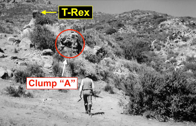
We can't talk about the Backyard Rocks without mentioning one of the area's most enigmatic features from the "Gunsmoke" days. I call it "T-Rex," and I'm afraid I have to start by breaking the news that it no longer exists.
 T-Rex stands tall near the Backyard Rocks
After spending some time looking at shots of T-Rex, I've concluded that it was a fake rock. It was presumably built for "Gunsmoke," although it did make cameo appearances in a few other shows.
 "South Wind": T-Rex and the Backyard Rocks, approaching from the south
T-Rex was usually seen adjacent to the Backyard Rocks. My gut tells me "Gunsmoke" may have relocated it once or twice for other episodes, but I have yet to find the "smoking gun" that might prove that theory.
 T-Rex lurks behind a camo bush
In this shot from "South Wind," a man arrives at the Backyard Rocks from the south. Once again we see the proximity of T-Rex to the Backyard Rocks, but from almost the opposite of the "Twenty Miles From Dodge" angle.
 Approaching the Backyard Rocks from the south today
Arriving at the Backyard Rocks/T-Rex area today from the south, we are again greeted by Clump "A," while T-Rex is nowhere in sight. This angle also provides some interesting context, courtesy of the Simi Ridge.  Nature and civilization in harmony?
I like this angle, despite the fence and other signs of development. Even the power pole has something to add, helping to define the contemporary setting for the Backyard Rocks in an unusual way.
 The Backyard Rocks and their neighbors to the south
As we close in a bit on the Backyard Rocks and Clump "A" from the south, we get a look at some of the other nearby rock features.
 Rocks of interest, on the "right" side of the fence
In particular, this pile of bleached rocks situated immediately south of the Backyard Rocks is of interest. These rocks are outside the backyard fence on public land.
 Are these "Gunsmoke" rocks too?
It seems inevitable that these rocks would also turn up in "Gunsmoke" episodes, although it may be a challenge to match them up with the show.
 "South Wind": The southern approach to T-Rex and the Backyard Rocks
Examining another shot from "South Wind," the rock indicated here with the green arrow struck me as looking suspiciously like one of the rocks in the bleached rockpile.
 The same rock seen in "Gunsmoke"?
I have a feeling this is the same rock, although I couldn't swear to it. It's also worth noting that some of the rocks may have been moved around when the neighborhood was being developed.
 "Abe Blocker" (Nov. 24, 1962): Matt rides up toward T-Rex
T-Rex also appears in the "Gunsmoke" episode "Abe Blocker," so we know the fake rock was in place as early as 1962. Here's a shot of Matt's horse's patootie as Matt rides up toward T-Rex, at top left.
 "Double Entry": T-Rex dwarfs Matt, bottom right, in the episode's final scene
A poignant overhead shot from the closing sequence of "Double Entry" provides additional perspective on the juxtaposition of T-Rex and the Backyard Rocks.
 T-Rex and the Backyard Rocks accent the episode's closing moments
This unusual shot gives us a chance to finally see T-Rex and all three of the main components of the Backyard Rocks on the screen at the same time.
 "Twenty Miles From Dodge": The man on T-Rex keeps an eye on Matt, Festus and others
While the towering T-Rex contributes significantly to multiple "Gunsmoke" episodes, its tour-de-force "performance" has to be when it plays that sentry tower for an outlaw gang in "Twenty Miles From Dodge."
 "Twenty Miles From Dodge": A stuntman earns his pay
Being stationed on top of T-Rex ultimately proves to be hazardous to the sentry's health. During a contentious moment in "Twenty Miles From Dodge," a guy does a pretty wild stunt fall off the fake rock.
 "Twenty Miles From Dodge": The plateau where the hostages were held
T-Rex, which would be just off camera to the left in this shot, overlooked a plateau where the outlaw gang had set up a corral and other facilities for holding hostages. I call this location "Twenty Mile Plateau."
 The location of the hostage plateau in today's North Ranch
The plateau was situated approximately where the Golden Sky Circle and Smokey Ridge cul de sacs can be found in today's landscape, part of the residential Westlake Village community of North Ranch.
 "Twenty Miles From Dodge": The view from the hostage plateau
The view from Twenty Mile Plateau, looking south over the full span of Lindero Canyon, is spectacular.
 The same view as it appears today
While it's harder today to avoid signs of civilization, the vista remains impressive — and it's a nice match for the view we see in "Gunsmoke." Notice how virtually all of the same background hills appear in the above two photos.
 "The Virginian" episode "The Claim": Following in "Gunsmoke's" footsteps
"The Virginian" began filming in the same area around the time "Gunsmoke" was working on some of its "T-Rex" episodes, and the fake rock crept into a few "Virginian" scenes too.
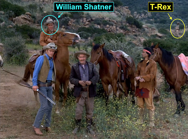 The soon-to-be Captain Kirk guests on "The Virginian" — and shares the screen with T-Rex
Not long before he started appearing as Captain Kirk on the new series "Star Trek" in 1966, William Shatner was a guest on the 1965 "Virginian" episode "The Claim," where he worked alongside "Gunsmoke's" T-Rex.
 "The Virginian": Shatner's close encounter with T-Rex
Shatner didn't have much interaction with the rock tower, but I like to think the appearance may have had an impact on the actor's career going forward.
 "Star Trek" episode "Arena" (1967): Kirk vs. the Gorn at Vasquez Rocks
It wasn't long after Shatner was seen hanging out around T-Rex that someone got the idea to pair him up with another dinosaur-like figure — the Gorn — in one of the most memorable "Star Trek" episodes.
 Closing scene from "Double Entry": A dejected Matt heads out as the credits roll
If Matt appears deflated in this shot from the final sequence in "Double Entry," it's probably because (spoiler alert) the guy who was dangling from Monkey Rock ... well, let's just say things didn't turn out so well for him.
 One of the area's landmarks
R.I.P., dangling man ... but I wanted to point out this interesting cluster of rock pillars just up the hill. They're about a stone's throw from most of the rocks we've been looking at.
 The same cluster of pillars in 2021
This cluster is one of the location's key landmarks, and it comes up more than once in "Gunsmoke." Here we see it on a recent expedition to the site, sort of from the "Double Entry" angle.
 Moving in for a closer look
Here's a closeup of the cluster of rock pillars.
 The same group of rocks from a different angle
Like most rock formations, this one has a tendency to shape-shift when viewed from different angles.
 The cluster of pillars, looking north
Here we're looking north toward the formation.
 "Double Entry": The stage rumbles toward the cluster of rock pillars
This angle, too, turns up in "Gunsmoke."
 Thar she blows!
Not that there was any doubt, but I've circled the rock cluster to make sure we're all on board.
 The cluster and its place on the hill
One last look at the current layout, from an angle approximating the "Double Entry" stage shot.
 "Double Entry": Matt investigates a mine entrance
A few features remain elusive, while others appear to have been lost to development. One example is this mine, which can be seen in one or two "Gunsmoke" episodes.
 "Double Entry": Clues to the mine location
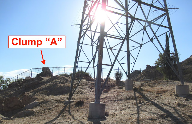
It appears that the mine was situated just south or southeast of the Backyard Rocks, somewhere close to that one main power pole that keeps popping up. But nailing down the mine location is far from a done deal.  The mine with its high-profile neighbors
The wide shot from "Double Entry" provides a number of clues, placing the location of the mine in proximity to various rock features.  "Double Entry": Turkeyhead Rock, guardian of the mine
The mine closeup provides additional clues, not the least being a rock just above the mine entrance that bears a resemblance to the head of a turkey. In my usual knee-jerk fashion, I've started calling it Turkeyhead Rock.  Turkeyhead's more famous neighbor
It turns out one of Turkeyhead's closest neighbors is our old friend Clump A, of the Backyard Rocks. In theory, this should help us figure out the mine location, but the reality is the location remains problematic.
 As the sun sinks in the West behind the Backyard Rocks and the tower of power ...
One problem is the ethereal Clump A, which looks different from every angle — and looks different today from how it looked in the "Gunsmoke" days. Here we're peering through the fence at its eastern silhouette.
 Do the clump and the power pole hold the secret to the mine location?
It's the wrong time of day to be shooting in this direction, but a bigger issue here is that massive power pole. I know I said nice things about it a while ago, but to be perfectly honest ... that pole is starting to get under my skin.
 Just thinking out loud here ...
In fact, I'm starting to wonder whether the power pole may have had something to do with the destruction of the mine. I would love to say hey look, there's the old mine entrance, but I don't think the answer is that simple.
 Clump A reveals its inner arch
On another trip to the site, with better lighting, I was able to get this shot of Clump A. Taken just a few feet from where I took the previous shot, this angle reveals that the rocks at the top of Clump A form an arch.
 The "debris field" may have its own stories to tell
Also of interest are the rocks strewn about in what amounts to a debris field east of Clump A — including at least one Turkeyhead-type rock whose presence in the pile raises possibilities for future expeditions.
 The trailhead on Pathfinder, heading north (Google Street View)
The rocky "Gunsmoke" location is not accessible by car, but a public hiking trail runs right through it. I entered the trail from Pathfinder Avenue just east of Falling Star, at the "no man's land" mentioned earlier.
 The north end of the Lindero (image rotated 90 degrees)

There's a hiking trail to help you get there, but as you might be able to tell, it's all uphill.

I like to think about what it must have been like for the "Gunsmoke" crew to arrive in this picturesque spot back before all the houses, power poles and other signs of "progress" started chipping away at the view.

One of the first things the crew would have spotted is this rock, one of the most prominent features of the landscape. Known to some local residents as "Monkey Rock," it would become a familiar sight in "Gunsmoke."

Here's a little better look at Monkey Rock, at top right. It wouldn't be possible to get this shot today because the open area below Monkey Rock is now filled with suburban homes.

This photo from a recent visit to the site gives an idea of how Monkey Rock coexists today with the homes, power lines and other amenities of the contemporary landscape — along with the Simi Ridge towering behind it.

Monkey Rock provides the focal point for an action sequence in the season 10 "Gunsmoke" episode "Double Entry," where the rock's eastern profile is featured.

After seeing the layout in person, I know I wouldn't want to be the guy dangling from Monkey Rock.

While I couldn't quite replicate the shots of Monkey Rock as it appears in "Double Entry," I did get this view of the rock's eastern profile.

The angle is pretty close between the recent photo and this zoomed-in version of the stagecoach shot.

A short distance east of Monkey Rock a cluster of rocks can be found in the backyard of a house all the way at the end of the last cul de sac in the northeast corner of Westlake Village.

I call them the "Backyard Rocks" because they're pretty much the only significant rock formation in any backyard in the neighborhood — and they made a number of appearances on "Gunsmoke."

Taking a closer look at the Backyard Rocks, we can identify three main clumps, labeled here as "A," "B" and "C." These rocks remain surprisingly intact today considering their proximity to residential development.

Clumps "A" and "C" are visible in the shot of Quint and Matt, while Matt's head blocks the view of Clump "B."

In another shot from "Abe Blocker," Matt can be seen walking his horse below the Backyard Rocks, with Clumps "A" and "B" readily identified.

Being the highest and some might say most interesting of the three main rock formations, Clump "A" is sort of the "alpha rock" of the Backyard Rocks. It's also the most prolific when it comes to on-camera appearances.

The Backyard Rocks turn up again in the 1965 episode "South Wind."

We can't talk about the Backyard Rocks without mentioning one of the area's most enigmatic features from the "Gunsmoke" days. I call it "T-Rex," and I'm afraid I have to start by breaking the news that it no longer exists.

After spending some time looking at shots of T-Rex, I've concluded that it was a fake rock. It was presumably built for "Gunsmoke," although it did make cameo appearances in a few other shows.

T-Rex was usually seen adjacent to the Backyard Rocks. My gut tells me "Gunsmoke" may have relocated it once or twice for other episodes, but I have yet to find the "smoking gun" that might prove that theory.

In this shot from "South Wind," a man arrives at the Backyard Rocks from the south. Once again we see the proximity of T-Rex to the Backyard Rocks, but from almost the opposite of the "Twenty Miles From Dodge" angle.

Arriving at the Backyard Rocks/T-Rex area today from the south, we are again greeted by Clump "A," while T-Rex is nowhere in sight. This angle also provides some interesting context, courtesy of the Simi Ridge.

I like this angle, despite the fence and other signs of development. Even the power pole has something to add, helping to define the contemporary setting for the Backyard Rocks in an unusual way.
As we close in a bit on the Backyard Rocks and Clump "A" from the south, we get a look at some of the other nearby rock features.

In particular, this pile of bleached rocks situated immediately south of the Backyard Rocks is of interest. These rocks are outside the backyard fence on public land.

It seems inevitable that these rocks would also turn up in "Gunsmoke" episodes, although it may be a challenge to match them up with the show.

Examining another shot from "South Wind," the rock indicated here with the green arrow struck me as looking suspiciously like one of the rocks in the bleached rockpile.

I have a feeling this is the same rock, although I couldn't swear to it. It's also worth noting that some of the rocks may have been moved around when the neighborhood was being developed.

T-Rex also appears in the "Gunsmoke" episode "Abe Blocker," so we know the fake rock was in place as early as 1962. Here's a shot of Matt's horse's patootie as Matt rides up toward T-Rex, at top left.

A poignant overhead shot from the closing sequence of "Double Entry" provides additional perspective on the juxtaposition of T-Rex and the Backyard Rocks.

This unusual shot gives us a chance to finally see T-Rex and all three of the main components of the Backyard Rocks on the screen at the same time.

While the towering T-Rex contributes significantly to multiple "Gunsmoke" episodes, its tour-de-force "performance" has to be when it plays that sentry tower for an outlaw gang in "Twenty Miles From Dodge."

Being stationed on top of T-Rex ultimately proves to be hazardous to the sentry's health. During a contentious moment in "Twenty Miles From Dodge," a guy does a pretty wild stunt fall off the fake rock.

T-Rex, which would be just off camera to the left in this shot, overlooked a plateau where the outlaw gang had set up a corral and other facilities for holding hostages. I call this location "Twenty Mile Plateau."

The plateau was situated approximately where the Golden Sky Circle and Smokey Ridge cul de sacs can be found in today's landscape, part of the residential Westlake Village community of North Ranch.

The view from Twenty Mile Plateau, looking south over the full span of Lindero Canyon, is spectacular.

While it's harder today to avoid signs of civilization, the vista remains impressive — and it's a nice match for the view we see in "Gunsmoke." Notice how virtually all of the same background hills appear in the above two photos.

"The Virginian" began filming in the same area around the time "Gunsmoke" was working on some of its "T-Rex" episodes, and the fake rock crept into a few "Virginian" scenes too.

Not long before he started appearing as Captain Kirk on the new series "Star Trek" in 1966, William Shatner was a guest on the 1965 "Virginian" episode "The Claim," where he worked alongside "Gunsmoke's" T-Rex.

Shatner didn't have much interaction with the rock tower, but I like to think the appearance may have had an impact on the actor's career going forward.

It wasn't long after Shatner was seen hanging out around T-Rex that someone got the idea to pair him up with another dinosaur-like figure — the Gorn — in one of the most memorable "Star Trek" episodes.

If Matt appears deflated in this shot from the final sequence in "Double Entry," it's probably because (spoiler alert) the guy who was dangling from Monkey Rock ... well, let's just say things didn't turn out so well for him.

R.I.P., dangling man ... but I wanted to point out this interesting cluster of rock pillars just up the hill. They're about a stone's throw from most of the rocks we've been looking at.

This cluster is one of the location's key landmarks, and it comes up more than once in "Gunsmoke." Here we see it on a recent expedition to the site, sort of from the "Double Entry" angle.

Here's a closeup of the cluster of rock pillars.

Like most rock formations, this one has a tendency to shape-shift when viewed from different angles.

Here we're looking north toward the formation.

This angle, too, turns up in "Gunsmoke."

Not that there was any doubt, but I've circled the rock cluster to make sure we're all on board.

One last look at the current layout, from an angle approximating the "Double Entry" stage shot.

A few features remain elusive, while others appear to have been lost to development. One example is this mine, which can be seen in one or two "Gunsmoke" episodes.

It appears that the mine was situated just south or southeast of the Backyard Rocks, somewhere close to that one main power pole that keeps popping up. But nailing down the mine location is far from a done deal.

The wide shot from "Double Entry" provides a number of clues, placing the location of the mine in proximity to various rock features.

The mine closeup provides additional clues, not the least being a rock just above the mine entrance that bears a resemblance to the head of a turkey. In my usual knee-jerk fashion, I've started calling it Turkeyhead Rock.

It turns out one of Turkeyhead's closest neighbors is our old friend Clump A, of the Backyard Rocks. In theory, this should help us figure out the mine location, but the reality is the location remains problematic.

One problem is the ethereal Clump A, which looks different from every angle — and looks different today from how it looked in the "Gunsmoke" days. Here we're peering through the fence at its eastern silhouette.

It's the wrong time of day to be shooting in this direction, but a bigger issue here is that massive power pole. I know I said nice things about it a while ago, but to be perfectly honest ... that pole is starting to get under my skin.

In fact, I'm starting to wonder whether the power pole may have had something to do with the destruction of the mine. I would love to say hey look, there's the old mine entrance, but I don't think the answer is that simple.

On another trip to the site, with better lighting, I was able to get this shot of Clump A. Taken just a few feet from where I took the previous shot, this angle reveals that the rocks at the top of Clump A form an arch.

Also of interest are the rocks strewn about in what amounts to a debris field east of Clump A — including at least one Turkeyhead-type rock whose presence in the pile raises possibilities for future expeditions.

The rocky "Gunsmoke" location is not accessible by car, but a public hiking trail runs right through it. I entered the trail from Pathfinder Avenue just east of Falling Star, at the "no man's land" mentioned earlier.

This is what I'm calling the "no man's land," which appears here like a strip of dirt at the center of the map. This strip extends the line of the Lindero north beyond Lindero
Canyon Road, which veers off to the east.
 "No Man's Land": The old boundary between the ranches
I don't know the backstory on why this strip of land was set aside, but one thing it's used for today is hiking. Technically, this means it's not really a "no man's land," but even so, the term seems to fit.
 Location of the trailhead leading to the "Gunsmoke" site — on Pathfinder Avenue
Fittingly, one of the keys to finding the path to the "Gunsmoke" location is to find Pathfinder Avenue, where the trailhead is located.
 Warning: We are about to "flip the pareidolia switch"
At this time, unless you're already up to speed on pareidolia, you may want to look it up. Or just avert your eyes.
 Shall we take a closer look at Turkeyhead Rock?
If you see a turkeyhead here — as I do — I hope you realize that your journey may be just beginning.  The Old Prospector
Digging a little deeper, it occurs to me that Turkeyhead Rock does not travel alone — it brings along its own "ghost figures." I call this one "The Old Prospector." Your mileage may vary, but I see him plain as day.
 The Warrior — or is it the Doorman?
I imagine I drive some of my readers crazy when I start pointing out ghost figures hidden in the rocks. But since I'm already a little crazy I suppose I'm just doing my part to help you catch up.
 They're still there ...
Even if you zoom right in, it doesn't seem to matter. I still see them, anyway — although sometimes the "warrior" looks more like a doorman. This is pretty subjective stuff — I hope some of you can conjure up your own "ghosts."
 Meanwhile, on a nearby rock ...
Even I have to admit this one's a stretch — but maybe you're lucky enough to see it. Sadly, I suspect I might be the only one who sees Pete Townshend doing "Pinball Wizard" here.
 Pete Townshend
Pete and I want to give a big shout-out to Aaron St. John, who has been my right-hand man throughout the "Gunsmoke" research and continues to make amazing finds. Rock on, my friend!
 More to come in the "On location with Gunsmoke" series
"On location with Gunsmoke" is an ongoing series on the Iverson Movie Ranch Blog. Below you will find links to previous posts in the series ...

I don't know the backstory on why this strip of land was set aside, but one thing it's used for today is hiking. Technically, this means it's not really a "no man's land," but even so, the term seems to fit.

Fittingly, one of the keys to finding the path to the "Gunsmoke" location is to find Pathfinder Avenue, where the trailhead is located.

At this time, unless you're already up to speed on pareidolia, you may want to look it up. Or just avert your eyes.

If you see a turkeyhead here — as I do — I hope you realize that your journey may be just beginning.

Digging a little deeper, it occurs to me that Turkeyhead Rock does not travel alone — it brings along its own "ghost figures." I call this one "The Old Prospector." Your mileage may vary, but I see him plain as day.

I imagine I drive some of my readers crazy when I start pointing out ghost figures hidden in the rocks. But since I'm already a little crazy I suppose I'm just doing my part to help you catch up.

Even if you zoom right in, it doesn't seem to matter. I still see them, anyway — although sometimes the "warrior" looks more like a doorman. This is pretty subjective stuff — I hope some of you can conjure up your own "ghosts."

Even I have to admit this one's a stretch — but maybe you're lucky enough to see it. Sadly, I suspect I might be the only one who sees Pete Townshend doing "Pinball Wizard" here.

Pete and I want to give a big shout-out to Aaron St. John, who has been my right-hand man throughout the "Gunsmoke" research and continues to make amazing finds. Rock on, my friend!

"On location with Gunsmoke" is an ongoing series on the Iverson Movie Ranch Blog. Below you will find links to previous posts in the series ...
11 comments:
What an exciting post! You do so much work in finding screencaps from the program to match up with the after location shot. And most of the time the angles are so accurate it’s easy to see the similarities. And so many from different programs. You must either have a photographic memory or do a lot of scanning. You’re right, these rocks are shape-shifters. Even a slight move and they look so different, which makes your matching them up more impressive. I love that the fence is still there. Wear and tear for sure, but when I think about the people who sunk the holes for the posts and strung the wire, I wonder if they ever thought it would last this long. Burned posts and all. It must have been fun for the Gunsmoke crew to arrive on location, even if it was hot and dusty. The rugged ridges and rocks scattered around are so perfect for playing historical cowboy games it seems wrong to see the wires strung through there. Yikes, those stunties sure earned their money, didn’t they? Wonder if the Backyard Rocks are ever going for a dip in that pool. Pretty amazing how they remained perched there during construction. Clump A is a star. If T-Rex was a fake rock, they did an excellent job in matching the texture of the rocks nearby. Also at the base, piling on the sand. Sometimes you can see fake rocks clearly sitting on top of the ground. Very impressive that you found shots of Clump A and T-Rex from a different angle in another ep. That South Wind rock pile does look suspiciously familiar. Love the Virginian photo with the signs pointing to Shatner and T-Rex, not two words you usually find in close proximity. I had to look up pareidolia but I’m totally on board with the Old Prospector and the Warrior. I am looking forward to hearing more about the mine and that’s a yes on Miss Kitty. Thanks for an awesome post! Caris
Thanks for the great feedback, Caris.
Whatever the opposite is of "photographic memory," that's what I have. When I get up in the morning I have to look for a Post-It hanging over the stove to figure out what I'm doing that day. I know I'll be at the stove because that's where the coffee is.
Putting the pieces together for this research just takes a lot of organizing, many hours spent poking at it and a lot of love of doing it.
Your interest in it is much appreciated.
... SN
Hi Dennis,
Another great vlog on about Gunsmoke locations. Its great that there are so much left to search for there,as other locations are swept up by civilization.Its a beautiful location,its a shame that they put all those house there,you can stop progress.looking forward to your next one.your hard work is really appreciate.
stephen
p.s.I wonder do the people in those houses,know they are living where famous westerns,tv western were made.
Another great in depth post on the day's we seem to yearn for. It was a pleasure being able to accompany you on part of your journey to uncover the past and bring it to life for us. thanks again for all your hard work.
Thanks for your comments, Stephen and Cliff. Yeah, we do have a blast doing this stuff!
Stephen, I did talk with some of the residents of the area where Gunsmoke did most of the shooting documented in this post. The ones I talked to didn't know anything about it. I know some of the local residents are well aware, but I think they're in the minority.
... SN
Can't add anything to what has already been said except it's a thrill to see posts such as this. Thanks for your efforts and willingness to share.
Great stuff as usual. Last spring, I watched all 20 seasons of Gunsmoke so this is really interesting to me. My favorite show Zorro also used the Albertson Ranch for a few episodes. Great job, take care
best
gerry dooley
Forgot to add I found this pic on pinterest and I think it shows T-Rex! here is the url where I found it.
https://pin.it/2txiaJl
and another just for fun;
https://pin.it/5DRwaS8
This place hasn't changed at all!
Love this post. The opening sequence of Old Yeller was filmed a stone's throw away from here, down around where the shopping centers are now at the corner of Lindero Canyon and Kanan, based on the angles and matching the ridgelines. When I was a kid, there were ruins of the Western town where the Vons Pavilions stands today. Big Valley was filmed here as well. Some of the stately oaks in the old films still stand, but they're getting harder to ID with all the other trees around.
Gunsmoke turned Simi Ridge into an iconic Western backdrop, using its striking landscapes to create unforgettable scenes. Its cinematic legacy lives on through expertly crafted storytelling. At Polish Fixer, we bring the same commitment to detail and production excellence. Let us help bring your creative vision to life! Visit https://polishfixer.com/
Post a Comment